Blog entries tagged with "road trip"
Sunday, September 28th, 2014 at 05:51pm
Starting with the three week road trip to Perth and back I used the OziExplorer Android app with NATMAP Digital Maps. These maps do not have the best detail, they have been reliable and I trust them. As well as having it show a moving map, I would pore over them in advance to plan where we would go and if there were any interesting things to stop at.
I did pay for the official OziExplorer app, but it always bugged me that it lacked a certain Android-ness, eg it couldn’t stay running in the background so switching over to a browser to look something up stopped the map. I don’t know when it was, but as soon as I found out about Androzic I switched. It is a shame that changes to the OziExplorer app have been around a new proprietary map format instead of a better user experience.
Before I start talking about what I am switching to, I want to point out that you can download the NATMAP maps for free and Androzic is also free. To combine the two you just need to find an older version of the img2ozf tool to make ozf2 or ozf3 files…
When I was in Perth for LCA2014 at the start of the year there was a keynote about using OpenStreetMap tools and data for disaster relief. This along with talking to people reminded me that it had been a while since I had looked into it. After the conference I was hiring a car to spend a few days driving up the coast, in preparation I had made sure that I had the appropriate NATMAP maps on my phone. I had nothing to loose by installing OsmAnd and downloading the map data for Australia, but I could gain up to date map data along with the ability to search and use navigation.
This worked out well for that trip and I played with it a couple of other times, including on a long weekend to Marysville with the camera club (I noticed one missing road in the OSM data). Though when we went up to the high country for the Easter long weekend I switched back to Androzic to use both NATMAP and HEMA maps. On my US trip I relied upon OSM map data while driving through Arizona (as I had no idea what kind of mobile reception there would be) and also used it for the couple of days I had a car in San Francisco.
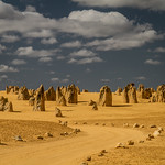
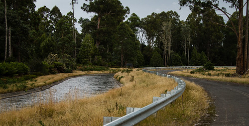
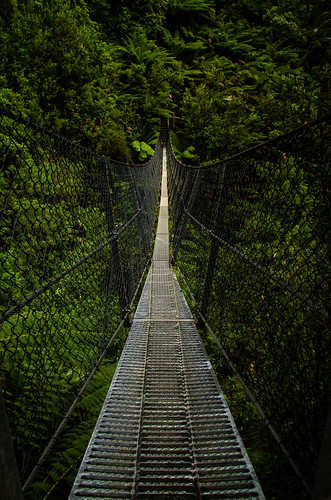
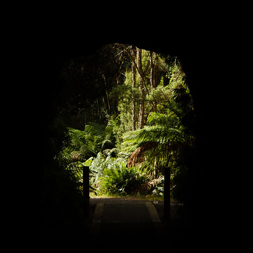
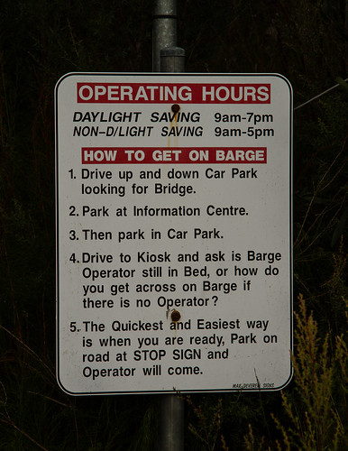
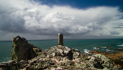
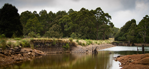
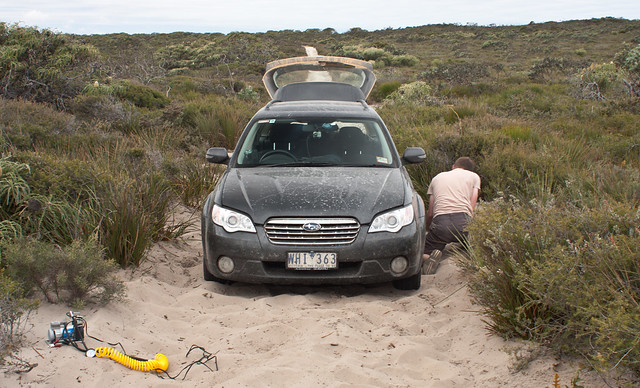
Over time I have built up a list of potential photo spots, yesterday I headed out to check out a few of them which included the Pound Bend Tunnel, a tower at Kangaroo Ground and The Blacksmiths’ Tree in Strathewen. I had prepared a gpx file with waypoints which I loaded into OsmAnd, it was then a matter of selecting the appropriate point and telling it to navigate…
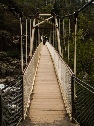
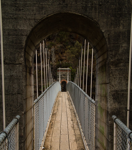
This worked well except for one location which was a bridge over an old aquaduct, the issue being that the OSM data thought you could drive down a lane and over the bridge, except you couldn’t. This resulted in a wrong turn at the time and today I created an OSM account and made my first edit to show that the bridge was closed to cars, but you could still walk across it.
I also read up about how to use GPS tracks with OSM and have been playing around with the online editor and the JOSM client to compare some of my tracks against the map data and other people’s tracks. In addition to the missing road near Marysville, I have spotted that another track near Bright is missing. Apart from those, I am quite impressed by how many of the forest tracks have data and how well they match against my GPS track. I think I will use OsmAnd on the next road trip, keeping NATMAP data as a secondary source.
The GPS unit that I use to log both the road trips and photo walks is a Garmin Vista HCx (previously I used a Legend Cx) which is intended for bushwalking. Years ago I did buy some Australian maps for it, but they are now out of date so instead the unit now has maps built from OSM data.
It also might take me a while to get caught up with my past track logs (need to clean them up a bit before uploading), but my plan is to include contributing the tracks to OSM as part of my photo geotagging workflow.
Tagged with: maps, osm, road trip
Saturday, July 19th, 2014 at 03:23pm
Five days ago I picked up a rental car, and then proceeded to drive over a thousand miles on the wrong (not to the locals though) side of the road.
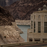
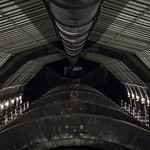
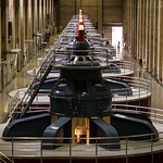
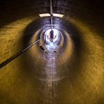
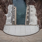
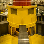
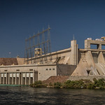
My first stop was to the Hoover Dam where I walked around, took a tour and overall marvelled at the engineering involved:
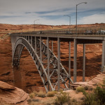
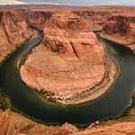
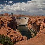
The next day it was time to head west from Las Vegas, after leaving Nevada I would cross back and forth between Utah and Arizona a couple of times before ending up at Page. There are a few national parks that I would have loved to detour to, but I didn’t have the time, I did fit in a tour of the Glen Canyon Dam and stopped by the well-photographed Horseshoe Bend:
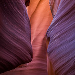
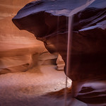
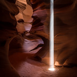
My main reason for visiting Page was for the nearby slot canyons. These are well known – one appears in the default Windows wallpapers – and I found that there was one group that has a dedicated photography tour. I opted for the half day tour which included three canyons, only one of those being the popular Antelope Canyon:

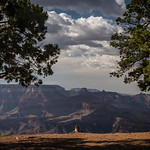
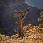
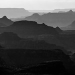
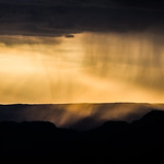
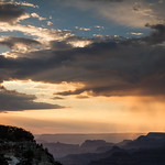
After spending the morning in slot canyons, the remainder of the day was spent driving down to and then along the rim of the Grand Canyon before trying to capture the sunset:
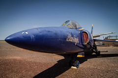
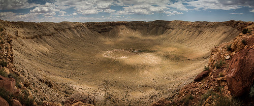
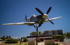
Heading south I stopped briefly at an aircraft museum and passed through Flagstaff on my way to a big hole in the ground, Meteor Crater:
It was now time to head west along parts of the old Route 66 before stopping at another dam and then back to Las Vegas:
Tomorrow I fly up to Portland, Oregon for a couple of days sightseeing and then OSCON, a huge open source conference.
Tagged with: photos, road trip
Thursday, January 30th, 2014 at 11:28am
Last year when I posted that things were going to be different there was something I didn’t mention, because I hadn’t yet made the decision. I was going to be flying over to Perth for LCA in January, and since I no longer had to get back to go to work I pushed my return flight back a week. If I am going to be flying all the way across the country, why not take photos of some of the sights? It is not that long since I was last in Perth, but on that try Perth was just a stop, the purpose of the trip was the journey. This time I could wander around and hopefully find interesting things.
Again I intend to write up another post about the conference itself (though I never wrote up anything about Canberra last year), for now I will talk about what I did afterwards.
Initially I was flying home the day after (Saturday) the conference, because I would have to pay a change fee I ended up opting for a slightly cheaper flight back on the following Sunday. This was a dreaded red-eye, but I didn’t have work to go to on the Monday, and it gave me slightly over a week to explore.
I ended up splitting my time, the first four days exploring Perth and Fremantle, then I would pick up a car and drive north (and back) over the next four days.
What I didn’t expect was for this to coincide with a heatwave. I’m not a fan of walking around in 40+ degree heat, so the first few days were essentially heat out as soon as it was light for a couple of hours and then retire to my room. The consolation at least was that nobody was around that early and I didn’t have to deal with harsh light.
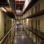
Once the heat broke I spent a day down in Fremantle, inclusing the Maritime Museum and former prison
I’m not sure where I found out about it, but on another hot day I caught the train out to the Aviation Heritage Museum in Bull Creek:
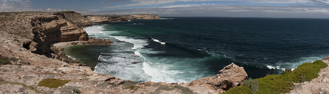
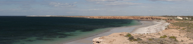
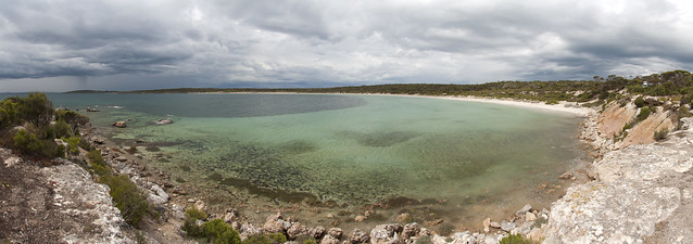
It was then time to pick up the hire car and head north, working my way along the coast as far as Kalbarri and then back on a more direct inland route:
I didn’t cover everything (often too hot to stray far from the car), but I have a better idea of the areas for the next time I go back.
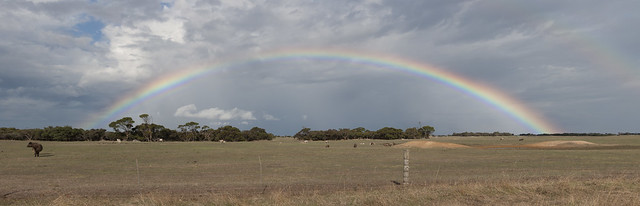
I was back in Perth for a day I drive around a bit to cover some areas that were not in walking distance of a station… (and the middle of the day was quite hot so I went to see a movie for the air conditioning)
It was good to get out with my camera, and while I should be starting to think about getting a new job I am spending more time on planning other trips, one over the easter weekend to the high country over easter and a big one to the US.
Tagged with: linux.conf.au, photos, road trip
Sunday, March 31st, 2013 at 10:07pm
Earlier this evening the driving portion of this road trip was completed when we arrived back in Devonport. Of course this was with just enough time to check into the motel, find some dinner and then get back to watch the new episode of Doctor Who.
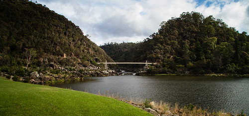
The day started in Launceston with a brief stop by the Trevallyn Dam and a lookout on the western side of town.
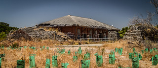
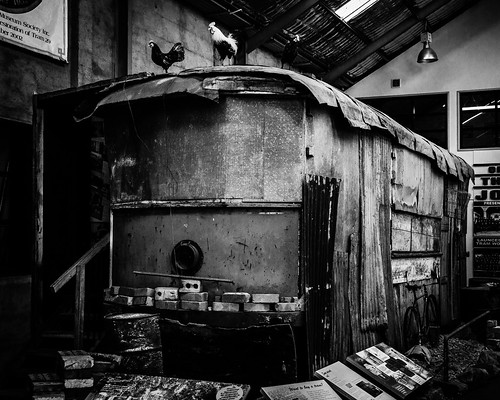
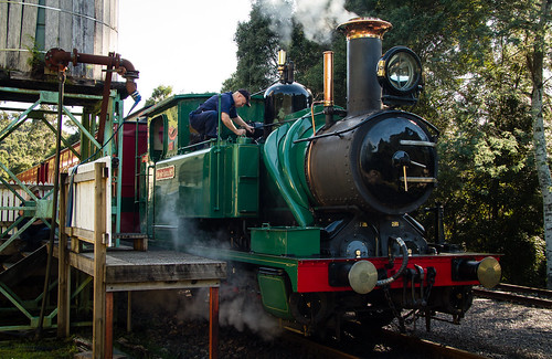
We then visited the Launceston Tramway Museum where it was quite interesting to see that although they only ever had 29 trams, they have managed to track down all of them. Of course not all have survived, some are being restored and this example has been retained as an example of the chook shed it had been converted into.
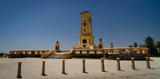
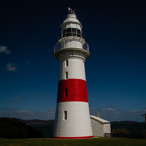
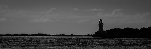
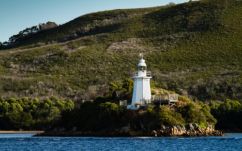
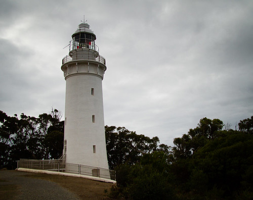
From Launceston we followed the eastern side of the Tamar River to George Town where we were lucky enough to arrive at lighthouse at noon, just at the time that they sounded the restored fog horn.
Heading back up the river we stopped at one of the old semaphore stations (that linked George Town with Launceston).
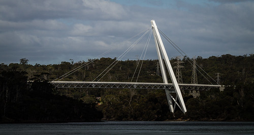
Crossing over the Tamar was via the Batman Bridge – the first cable-stayed bridge in Australia.
Now on the western side of the river we visited the mining museum at Beaconsfield, didn’t see much at Greens Beach, skipped visiting Port Sorell and then arrived in Devonport.
Although we did see the Spirit come into port at Devonport, our booking is for tomorrow (a day sailing) as we wanted to keep our last driving day flexible. We did ask if we could change our booking to tonights sailing, but it would have cost $300 to change it at this late stage…
Tagged with: photos, road trip, tasmania
Saturday, March 30th, 2013 at 09:45pm
As this road trip through western Tasmania draws to a close, today we travelleled north from Hobart to Launceston, but we didn’t just follow the main highway.
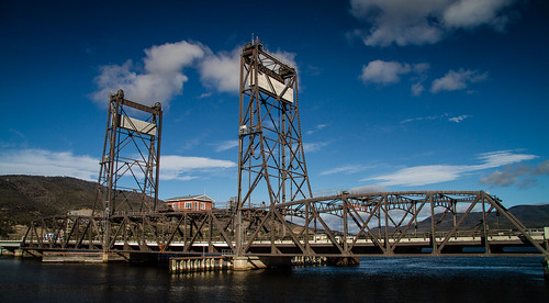
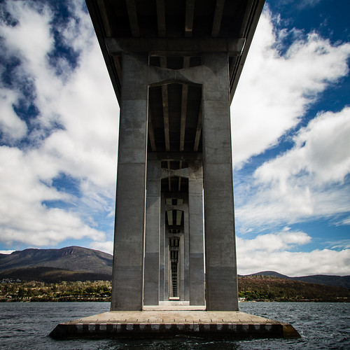
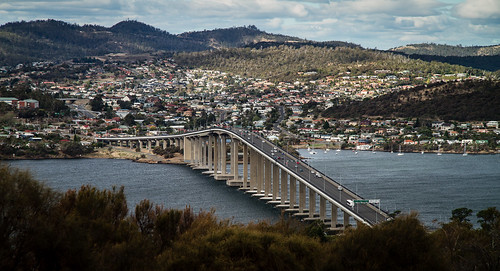
From Hobart we headed back up the Derwent River to have another look at its vertical lift bridge.
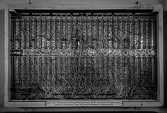
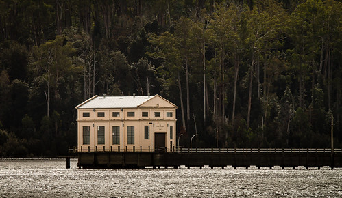
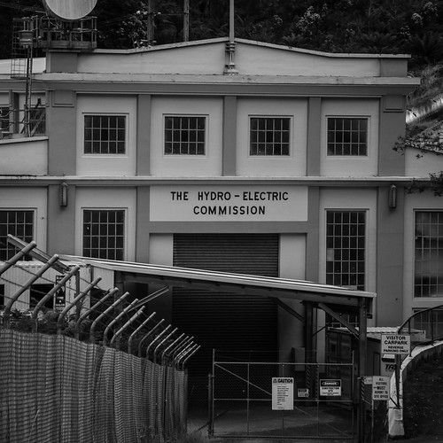
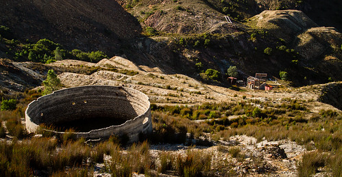
From there we continued north, but then turned off into the hills to the Waddamana Power Station Museum.
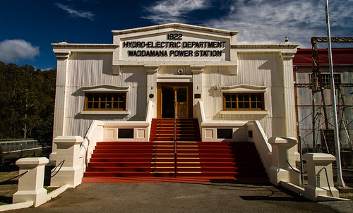
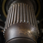
The museum was an excellent source for photos of old machinery and switching gear. This alone has provided many photos for me to sort through later.
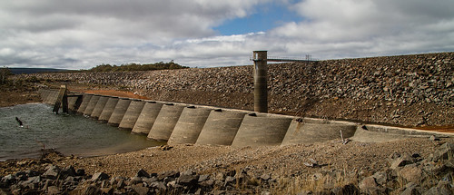
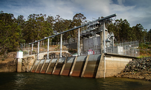
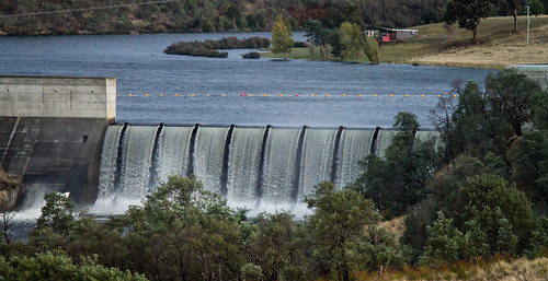
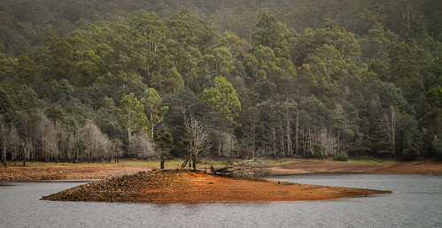
From Waddamana we headed up to the Miena Dam on Great Lake. The water level was low enough to expose the second Miena Dam (a series of concrete arches) behind the current rockfill dam. It wasn’t quite low enough to expose the first concrete dam, but it was just visible.
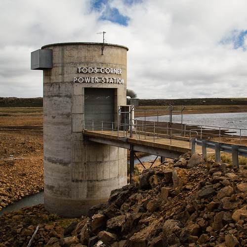
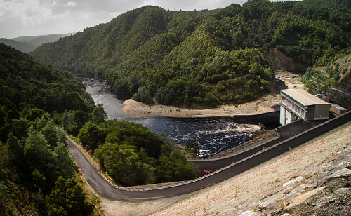
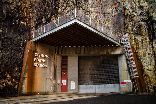
Around the corner from the Miena Dam was the outlet of the pipe where water is pumped up from Arthurs Lake. Here is a small power station that uses that water to reclaim some of the energy.
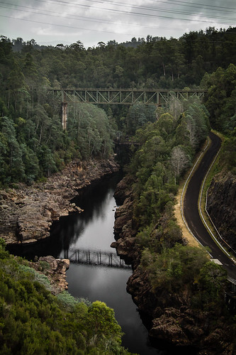
Continuing north we dropped down the Great Western Tiers and then arrived in Launceston in mid-afternoon. This gave us time to visit Cataract Gorge, both First Basin and the old Duck Reach power station.
We also drove around Launceston, noting the Tramway Museum for a visit tomorrow.
Tagged with: photos, road trip, tasmania
Friday, March 29th, 2013 at 10:15pm
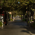
Our Tasmania road trip is almost over with today being a full day in Hobart. Today is also Good Friday. What is Hobart like on Good Friday? In our roaming around searching for things to do or see we did stop by the Waterfront and Salamanca Place. The former featuring a cruise ship in port and the latter the busiest place we saw all day.
After an early lunch we headed over the Tasman Bridge to the Rosny Hill Lookout, drove past the Bellerive Oval before stopping under the eastern approach to said bridge.
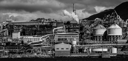
We then headed up the eastern side of the Derwent River, stopping at a few places which included shortly before the Bowen Bridge with a view across the river of the zinc smelter. (and the Incat shipyard, but nothing interesting was visible)
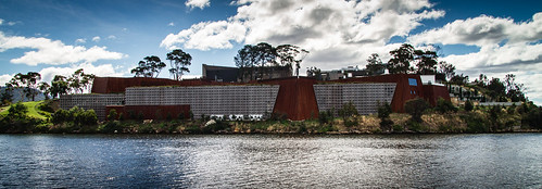
After crossing the river we headed over the the Tasmanian Transport Museum which we understood to be “open on Saturdays, Sundays and Public Holidays”. It seems that Good Friday isn’t a public holiday, as it was not open. With more time to kill, but not in the mood to look at actual art we found a place to photograph Mona from a distance.
Heading back south (we were working our way anti-clockwise) we stopped at the western approach to the Tasman bridge before heading up into Queens Domain. As we now expect, the view from the summit lookout was obscured by trees, but interestingly there was access onto a pair of huge water tanks, from which there was a clear view of the Tasman Bridge.
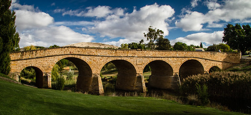
By now we had exhausted our short list of places to go, but it was only mid afternoon. To fill the time we brought forward our visit to Richmond from tomorrow. On the way we spotted some dishes not far from the road, which turned out to be the Mount Pleasant Radio Observatory.
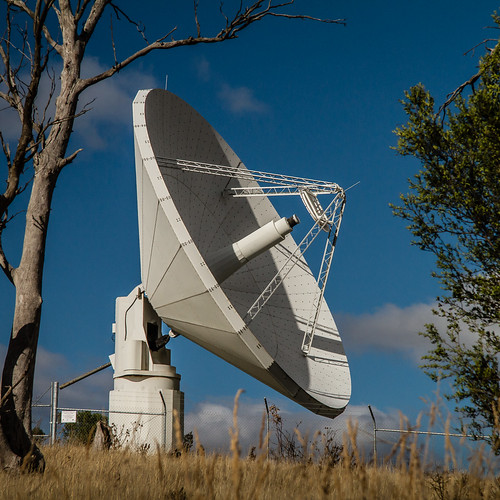
Later research informed us that one of the dishes (not the one pictured) is from the former Orroral Valley Tracking Station which we stopped at on a previous road trip.
Continuing on to Richmond we of photographed the bridge…
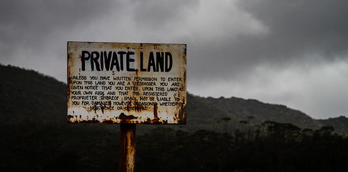
… before heading back to Hobart via Sorrell, Seven Mile Beach and even Rokeby where we spotted this sign.
Since we stopped via Richmond today, tomorrows plan is now to head straight for the Hydro Museum at Waddamana before ultimately ending up in Launceston.
Tagged with: photos, road trip, tasmania
Thursday, March 28th, 2013 at 11:06pm
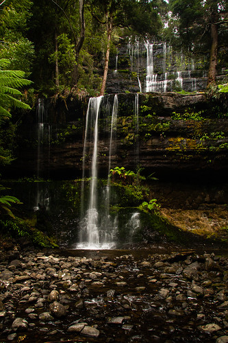
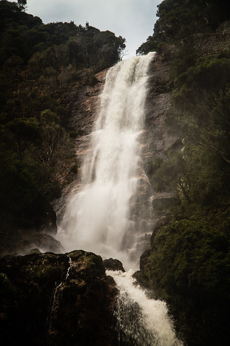
Today’s leg started out with a visit to Russell Falls, but there wasn’t much water flowing over them.
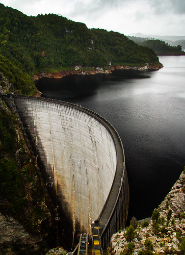
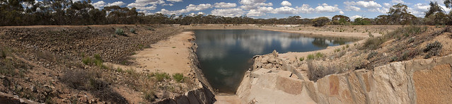
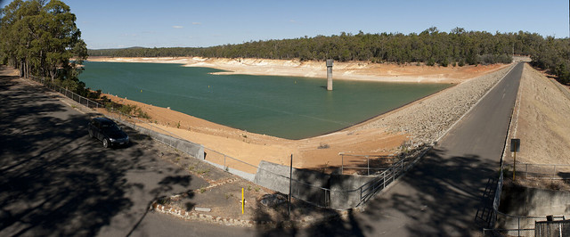
We then headed west to visit the Gordon Dam, a drive of approximately 200 kilometres return with not much to see on the way. It was also raining for most of the drive, we where lucky to get a couple of breaks while at the dam itself. We also stopped by the Serpentine Dam, but that is in no way as interesting to photograph.
Once we returned to the main highway, we followed the Derwent River all of the way into Hobart. In an attempt to catch the sunset we headed up Mount Wellington which was clouded in when we initially arrived, but we were lucky again as that cleared.
Despite it clearing, it was still cold and very windy, so we didn’t stay long. Instead opting to drive over to Mount Nelson and then down and through Hobart. This is the first of two nights in Hobart, we are still planning what to do tomorrow.
Tagged with: photos, road trip, tasmania
Wednesday, March 27th, 2013 at 10:02pm
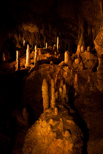
This morning our Tasmania road trip started the day with an underground tour of the Mount Lyell Mine. The tour took around three hours, covering the above ground and (more importantly) the underground operations of the mine. We didn’t go all of the way down, but we got to the crib room, saw underground workshops, the crusher, the main shaft, haulage trucks and all sorts of other things. The operations are quite a contrast to the tour of the Super Pit in Kalgoorlie that we went on two years ago during the Perth road trip.
Following the mine we stopped by the Spion Kop Lookout in town before heading east, where our day switched from mining to dams and power stations. Our first stop was at Lake St Clair, where we were not interested in the nature, but in the old pumping station.
Comtinuing on we started to pass the series of dams that supply the Tungatinah Power Station, including the intake portal.
Shortly after that we passed Tungatinah Power Station itself and then the Tarraleah Power Station on the opposite side of the river.
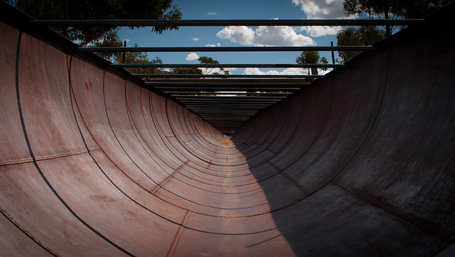
The old village for building Tarraleah is now part of a resort, but it does have a viewing platform above the penstocks.
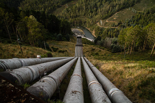
From there we followed the pipes, canals and aqueducts up to Clark Dam.
Our path then took up down the Derwent River where we spotted the spilling Cluny Dam, but only from a distance.
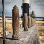
Our final dam visit was to the Repulse Dam, where they appear to be really keen about limiting loads over the bridge.
Since Tasmania has such a large number of hydroelectic power generation it is not surprising we are seeing so many, in fact we will see more tomorrow (Gordon and Serpentine) and in a few days time when we head back north.
Tagged with: photos, road trip, tasmania
Tuesday, March 26th, 2013 at 10:26pm
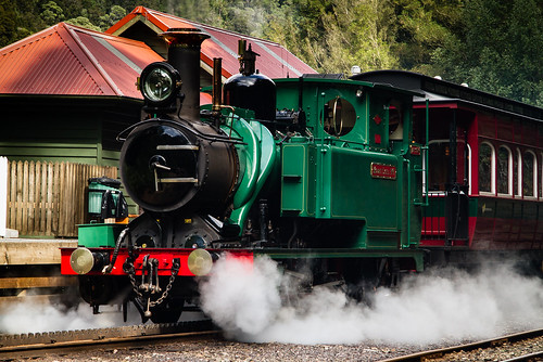
As mentioned yesterday, today’s leg of the Tasmania road trip included a trip on the Mount Lyell Railway West Coast Wilderness Railway. The current setup is that you ride the train one way, with a coach shuttle either at the start or end.
We opted for the 8AM coach from Strahan to Queenstown and then the train back to Strahan which would give us more time under our control, so we had four hours to drive ourselves to Queenstown and explore the nearby area. This included stops at the historic Lake Margaret Power Station, the old Iron Blow mine and dams south of Queenstown.
Even further south we found the Bird River Track which follows the route of the North Mount Lyell Railway and was a contemporary of the Mount Lyell Railway.
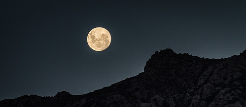
During the return to Queenstown there was interesting light over the hills around the slurry dam and the almost full moon was rising.
Tomorrow we will continue mine related activities with an underground tour of the Mount Lyell tour, followed by a long drive past Lake St Clair, past Tarraleah to arrive at Russell Falls in the Mount Field National Park before sunset.
Tagged with: photos, road trip, tasmania
Monday, March 25th, 2013 at 09:28pm
Today’s leg of the Tasmania road trip was quite short, this was to allow for the three hour return walk along the old route of the North East Dundas Tramway to the base of Montezuma Falls, the highest (at 104 metres) falls in Tasmania. Being the old tramway the walk was quite easy, with the old sleepers visible in sections.
Unfortunately the weather wasn’t the best to photograph the falls, photos of the suspension bridge (across where a trestle bridge used to be) were a lot better.
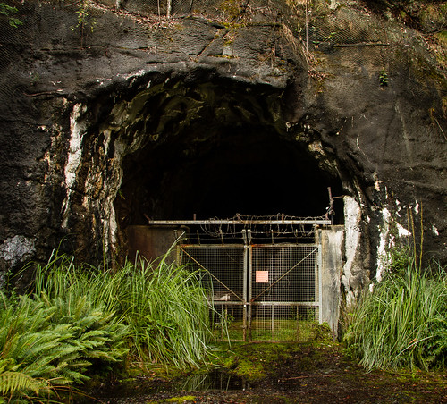
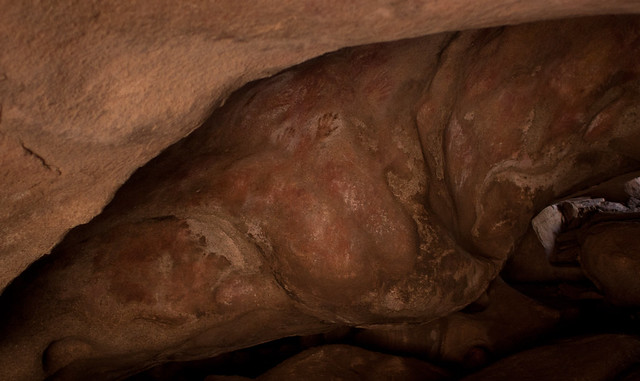
Once back in the car we looked around some of the other old mining area around Roseberry before heading to Zeehan which has a number of old buildings and a mining museum. There is also the Spray Tunnel, a tunnel that serviced the Spray Mine.
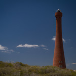
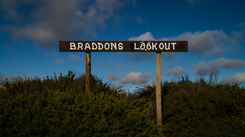
We then headed down to Strahan and after sorting out out (booked) ticked for the train tomorrow, we headed out to Braddon Point where we drove out onto the beach from where we could see the lighthouses at the entrance to Macquarie Harbour.
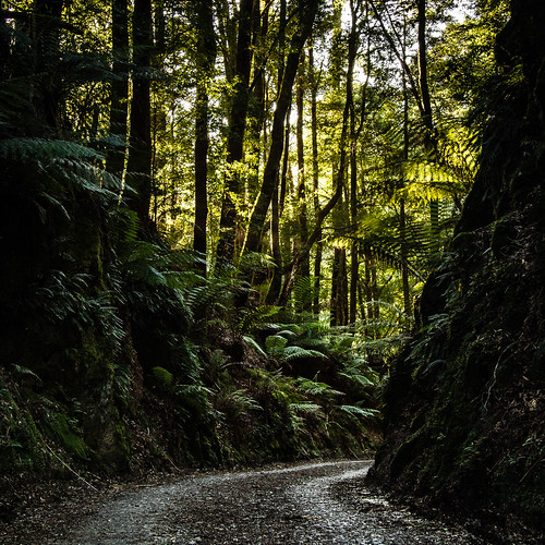
As the light changed we stopped be a jety, explored some forest tracks, picked up some dinner and then found a lookout over the town.
Our plan for tomorrow is also a short day, this time because of the West Coast Wilderness Railway.
Tagged with: photos, road trip, tasmania
Sunday, March 24th, 2013 at 09:20pm
Today’s leg of our Tasmania road trip started with water in one form, and then ended with water in another form.
The first form was the ocean, which we followed from Arthur River through Couta Rocks to Temma. We were surpised by how many coastal ‘shacks’ there were, most quite substantial and a few with slips for fishing boats.
After leaving the coast we followed the Western Explorer Highway south through a variety of environments before arriving at Corrina with its ferry across the Pieman River.
The remainder of the day was dominated by dams and power stations, of course with their water in a stored form. There were a number of them, including one that diverted water through a tunnel from one river system into a reservoir on another river system.
At one point we stopped at a lookout, one that was in need of some upkeep, a situation that we have often found.
Tomorrow we are off to Montezuma Falls (the highest in Tasmania) and then mining history at Zeehan.
Tagged with: photos, road trip, tasmania
Saturday, March 23rd, 2013 at 11:16pm
On day two of this road trip through Tasmania we travelled west along the north coast from Burnie and then south along the west coast to Arthur River. However we did start the day by heading inland to find Guide Falls, only one of the two waterfalls we were looking for today.

The weather was mixed, mostly heavy rain in the morning that was punctuated by patches of clear(er) sky. When it had just been raining and was still overcast the nice rich tones made themselves known.
Despite this, it was nice that as we returned to the coast we could see the rain moving away, where it stayed for most of the afternoon.
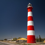
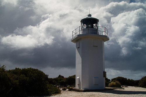
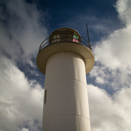
Which, being along the coast, featured a couple of lighthouses such at the one up on Rocky Cape.
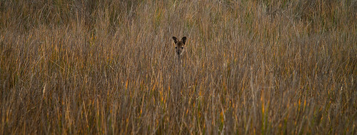
We started to see more wildlife.
At West Point we failed to find the lighthouse, just these concrete foundations.
At Bluff Hill Point we found a relatively modern (precast concrete, not stone, masonary or concrete in a form) lighthouse, it wasn’t until looking it up later that we found that when this was comissioned, it replaced the one at West Point that was subsequently removed.
These weren’t the only sights we saw, it is just that I need more time post processing those photos (in some cases that will mean assembling panoramas), but right now the day is over. Tomorrow is heading back inland, first along the Western Explorer Highway through the Tarkine region and then past mines and a number of dams.
Tagged with: photos, road trip, tasmania
Saturday, March 23rd, 2013 at 09:21pm
In the second day of our road trip we covered the coast of Tasmania from Burnie around to Arthur River, but before I describe that let us step back in time…
In late 2012 discussions about another road trip settled on Tasmania as the location and March/April 2013 as the time. To start keeping track of ideas we created a Google Map into which we added points of interest. This is that map as it stands today:
View Tasmania 2013 in a larger map
As our ideas started to firm up and we locked down dates, we turned to a Google Doc to plan out the itinerary. The days we had, where to stay, what to visit, the distances to travel, etc. At this stage we were realising that we only had ten full days available, and you cannot cover all of Tasmania in that time. So we decided to focus on the area to the north and west of Hobart. To visualise this we created another map (because Google Maps gets finicky when there are too many items) that showed the driving for each day:
View Tasmania 2013 – Driving in a larger map
Each day is a different colour (red, green, blue, red…) and it starts at Devonport and works counter-clockwise. In one sense this could be considered a sneak-peak about what my posts over the next eight days will be about…
Tagged with: road trip, tasmania
Friday, March 22nd, 2013 at 10:09pm
Twenty four hours ago I was about to pass through Port Phillip Heads on my way to Devonport aboard the Spirit of Tasmania. That was the start of a twelve day trip, ten of which involve driving around the north western areas of Tasmania.
After a very poor night’s sleep, we drove off the boat (from the very bottom garage deck) at around 6:30am, picked up supplies at a supermarket and then headed towards Cradle Mountain National Park, stopping at lookouts and dams along the way.
The plan had been to spend a couple of hours at Dove Lake, but the weather was so miserable and wet that we ate lunch in the car and decided to move on. A waterfall and old dam or so later we ended up back on the coast at Wynyard before heading to the accommodation we had booked at Burnie.
The plan for tomorrow is to start the day at the Hellyers Road Distillery (just for a tasting) before continuing along the coast, past The Nut at Stanley to end up on the west coast at Arthur River.
Tagged with: photos, road trip, tasmania
Wednesday, November 23rd, 2011 at 10:05pm
A few days ago I posted the map that was the plan for the Canberra to Cooma section of our road trip. Apart from skipping Corin Dam, it pretty much went to plan. The following day was Cooma to Merimbula via Bega and Tathra, we also kept to this plan:
View SE NSW 2011 Tuesday – Cooma to Merimbula in a larger map
We had a plan for today, head inland from Merimbula to lookouts, waterfalls and rainforest walks before looping back to Eden. We got to Wolumna Peak and started to head west to Myrtle Mountain via fire roads, but this happened:
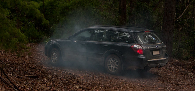
You see the dissipating smoke surrounding the car? That is the remains of the clutch…
The more dramatic action shot is:
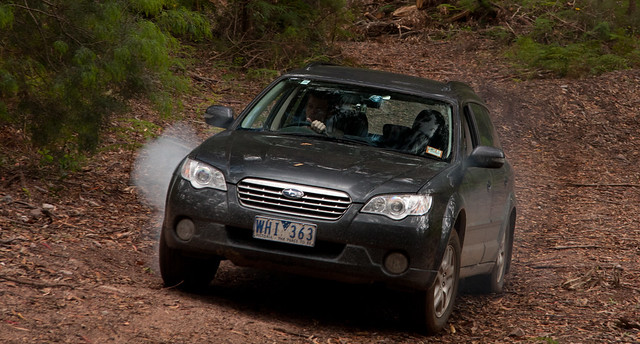
After this our priority was to get back to the main road, which we almost did until being stopped by a creek about 200 metres short. A 2km walk later we had enough phone reception to call RACV/NRMA. It took two hours for them to arrive, but they pulled us out and got the car to a mechanic in Bega. As it would take more than three days to fix (you do have to remove the whole engine and gearbox from the car) it will be towed back to Melbourne instead of being repaired.
But what about us? A taxi got us back to Merimbula to a motel (everything was booked in Bega) and we shall pick up a rental car tomorrow morning. All thanks to RACV Total Care.
Unfortunately we will only have the rental car for two days, and they are only paying for 200km per day. As the direct route from Merimbula to Melbourne is 560km, we will have to pay that difference plus that of any detours we make. It also means we will return to Melbourne a day earlier than planned. We are updating our itinerary now…
Tagged with: road trip
Monday, November 21st, 2011 at 08:33am
This foggy morning in Canberra marks the start of stage three of my trip, the spending of six days to return to Melbourne via the south east cost of New South Wales and Victoria.
Our immediate destination today is Cooma a town 115 kilometres south of Canberra. But we are not heading down the Monaro Highway to get there in 115 kilometres, instead we are heading into the hills on a path that will take us past construction of the new Cotter Dam, past the sites of old NASA tracking stations (one of which is Honeysuckle Creek) before reaching Lake Eucumbene which is part of the Snow Mountains Scheme.
View SE NSW 2011 Monday – Canberra to Cooma in a larger map
After Cooma the plan includes stopping at places such as Bega, Tathra, Merimbula, Eden, Mallacoota, Orbost and Lakes Entrance. Of course there are many planned side trips along the way.
In my initial post I said that OSDC was the first stage and the Warbirds Downunder airshow at the Temora Aviation Museum was the second. There is another stage, stage zero, which includes the afternoon I spend walking around Canberra before OSDC as well as yesterday spent driving around Canberra.
One thing is common to all of these stages: photos. Not many at OSDC, a huge amount at Temora and a moderate amount from Canberra. I will endeavour to get some of the up during the remainder of the trip.
Tagged with: road trip
Tuesday, November 15th, 2011 at 10:51am
Right now I am sitting at the airport, halfway through a hot chocolate and looking out over the planes taxiing up and down the apron.
This is just the first leg, the goal of which is to get to Canberra for the three day Open Source Developers Conference. While there were two days of miniconfs, I am not going to any of them. My plan for this afternoon once I arrive in Canberra is to be a tourist as this is only the second time in my memory (but not according to photo evidence…) that I have been there.
So far this is typical for me as I have been to every OSDC since they started in Melbourne many years ago. What makes this a multi-stage trip is what happens after.
On Saturday, the day after the conference, is an airshow. Not the Avalon one, but one held at the Temora Aviation Museum on Saturday. While I am at the last day of the conference, Damien (of the previous roadtrip) will be driving up from Melbourne to Canberra and then we will both head out to Temora that night ready for 8:30am entry to the airshow.
So an airshow is the second stage. The third is the largest as, after returning to Canberra for a day, we will be spending the next six days returning to Melbourne via the south east coast of New South Wales and Victoria. Before we get to the coast we will go through the hills behind Canberra, stopping off at the sites of the old tracking stations, you know, the one that actually received the moon walk broadcast…
As we return through the Lakes Entrance and Orbost area, it turns out that the Alpine Rally of East Gippsland is being run that weekend. It may be good if we can find a spectator location and get some good photos, but it might be bad if the forest roads we were planning of using through the state forest are closed. I was hoping we would know by now, but they haven’t released the spectator information.
Oh well, next stop Canberra.
Tagged with: airshow, osdc, osdc2011, road trip
Wednesday, July 6th, 2011 at 11:18pm
Ever since the topics were set for this year’s monthly competitions at the camera club, I have tried to keep them in mind when out shooting photos, in particular during the road trip earlier in the year.
The topic for July, judged last night, was “Landscape with a photographer” which was the incorporation of a photographer, in the act of taking a photo, within your landscape. Two of my four entries were from the road trip, but I am pleased to say that all four entries received an award.
Assembled using Hugin from 14 images and then printed as large as possible on A3+ paper was this image of Lucky Bay in Cape Le Grand National Park:

I am glad that the person walking along the beach had a camera and was using it because it was awarded highly commended and image of the month for A grade prints.
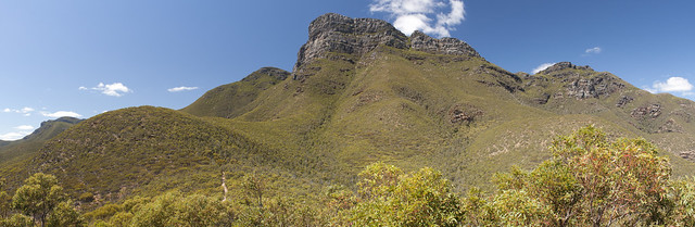
My second image from the road trip was as a digital entry and was taken from the top of Bluff Knoll, looking west along the Stirling Ranges.
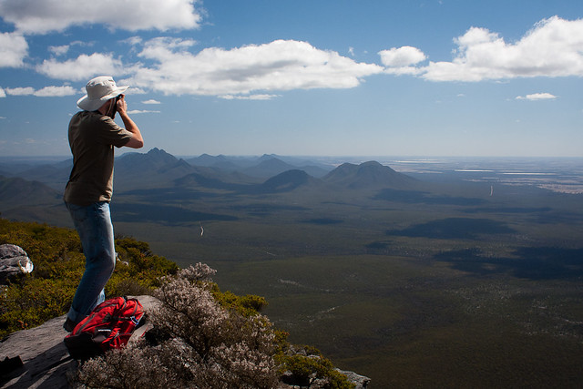
This was also awarded a highly commended.
My other digital entry was a panorama taken from Burke’s Lookout in the Dandenong Ranges, the photographer may look familiar:
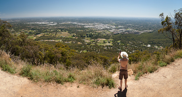
This recieved a merit.
My final image was a print and is my favourite, primarily because it features the newest addition to my camera bag, Lego 7567 Traveller:
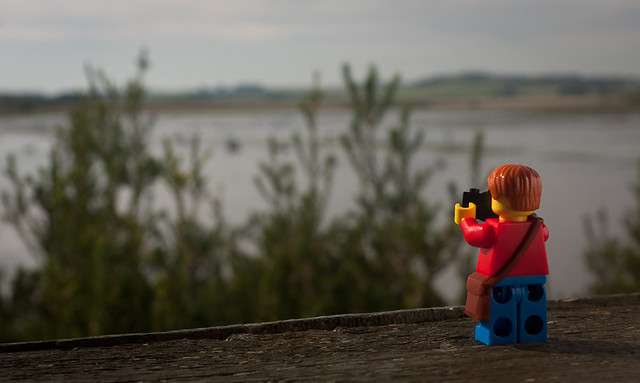
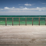
This was awarded a merit and was taken from one of the bird hides at Swan Lake on Phillip Island.
The remaining topics for the year include “man made timber structure in monochrome” and “sports action.” I have accumulated plenty of possibilities for the first topic, but expect to struggle for the second. However, I have an idea or two for posed minifigs.
Tagged with: road trip, waverley camera club
Saturday, April 30th, 2011 at 04:07pm
During my road trip I had two technology failures, a lens and a memory card.
Luckily there is a Canon service centre around the corner from work so it was a no-brainer to drop it off one morning before work. A little over two weeks later I returned, parted with $165 and have my everyday lens back. Being able to zoom again is quite handy.
The memory card wasn’t as straightforward. First I started off by contacting SanDisk to find out how a warranty claim would be affected by sending the card to a data recovery company. They said it would be ok so I posted the card to their recommended data recovery company in the UK.
The timeframe from me posting the card, the company advising what data they has recovered, me confirming the recovery, and return postage of the card and DVDs with the data also took a little over two weeks. Apart from the charge to my credit card, it was otherwise painless.
That was a few days ago and today I selected a few of them to add to the set on Flickr.
And those three images I had to ask you to pretend were in the previous blog post? How about these:
Tagged with: road trip
Monday, March 28th, 2011 at 10:44pm
On Saturday I sorted through my photos to ensure they were all correctly geotagged (almost exclusively based on the GPS track) and split them up into location based folders. Tonight I started running through the photos with the intention to pick a few to upload to Flickr.
I ended up chosing 91 images.
That is 91 images in addition to the 39 images I had uploaded throughout the trip. I have a couple more I might upload, plus a number of panoramas still to stitch and then review.
There are too many images to link to and describe individually, so just go to the Flickr set: Road Trip 2011 – Melbourne to Perth and back.
Originally I wanted to link to (or find a way to embed) the map of the Flickr set, but that view does not show all of the images on the map at the same time.
However, there is a solution in the form of Flickr Photo Set to KML which will generate a KML file of the entire set. My plan is to then add each day’s GPS track to the KML and make it available, embedding it in a blog post using Google Maps.
Give me a few days for that.
Tagged with: road trip
Friday, March 25th, 2011 at 10:27pm
The road trip is over. I am now back home with most things unpacked, a load of washing in the machine and am planning to have a nice long sleep in tomorrow.
There is nothing much to say about today, we left Renmark reasonably early then had a look around Mildura before heading towards Melbourne on the Calder Highway. Brief stops along the way included Wycheproof, Salt Lake, and Bendigo.
I still have a few posts planned and may photos to sort through. Hopefully I will get them done over the next week.
Tagged with: road trip
Thursday, March 24th, 2011 at 10:14pm
After another lateish start (we are glad to be arriving back home tomorrow) we headed out of Port Augusta towards Renmark, but of course we couldn’t go direct.
Heading out of town we followed the course of the old railway line towards Quorn, the terminus of the Pichi Richi Railway, an operating heritage railway that runs between Quorn and Port Augusta. We spotted many places for photo opportunities, but without a train, there was no reason to stop. It would be an interesting place to come back during school holidays, when they run steam trains on the line every day.
After a brief look around Quorn we headed over to the back of Mount Remarkable National Park to have a look at Aligator Gorge. Unfortunately the weather was dull and we didn’t see anything spectacular. Of course it was also quite busy and we had a hard time finding a parking spot.
Our next stop was at Clare for lunch. While this gives its name to the Clare Valley, known for Riesling wines, we didn’t stop at any wineries. We did see a F/A-18 circling above the road for a short distance, hopefully it was captured on the video. Our path also took us through Kapunda, Australia’s first successful metal mine, to view Map the Miner, a large statue of a miner.
The last part of the day followed the Murray River from Morgan to Renmark. Although we didn’t need to cross the river, we felt required to use a ferry to cross over, but then used a bridge to cross back. Along the way we detoured via Berri to get a photo of the, now closed, Big Orange. Apparently the biggest orange (of all the big oranges) in Australia.
Tomorrow is the drive home, probably via Mildura, Ouyen, Whycheproof and Bendigo.
Tagged with: road trip
Wednesday, March 23rd, 2011 at 10:02pm
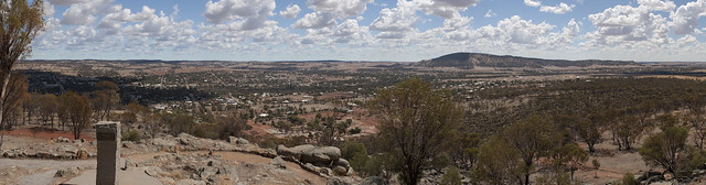
Today we traversed the top of the Eyre Peninsula from Ceduna to Port Augusta. On the way we learnt that it is known as granite country.
Of course, after a brief detour view the port of Thevenard, while our first destination was granite rocks, this was before ‘proper’ granite county started. The rocks in question being Murphy’s Haystacks which we had skipped on the outward part of the road trip due to poor weather. This time the weather wasn’t the best, but at least it wasn’t wet.
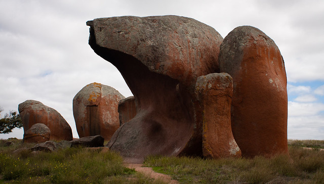
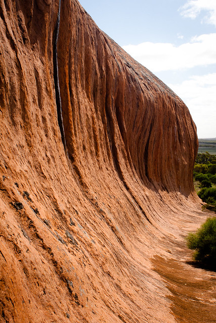
Our first stop in granite country was at Pildappa Rock, northeast of Minnipa. This rock has a similar wave structure to Wave Rock in Western Australia, but not quite as pronounced.
Further along the way we stopped by other rocks, such as Mount Wudinna, and also the Australian Farmer, a large statue carved out of the local granite. We also saw the Big Galah at Kimba before finally arriving in Port Augusta just in time to miss out on interesting light from the sunset.
Tomorrow is the second last day of the trip, we will travel through the southern Flinders Ranges and the Barossa Valley to get to Renmark near the border.
Tagged with: road trip
Tuesday, March 22nd, 2011 at 11:19pm
All of today and half of yesterday was all about driving. Driving the 1500 kilometres from Kalgoorlie in Western Australia all of the way acorss the Nullabor to Ceduna in South Australia. We have also lost two and a half hours due to the time zone change.
So why? Because this was mostly covering ground we had already covered.
On Monday we forced ourselves to get up early in order to make it to the Super Pit Tour. This is a two and half hour tour (mostly on a minibus) inside the KCGM area. While we didn’t actually go into the Super Pit, we did get to see it from internal lookouts as well as seeing the gold processing plant, truck workshops, and the trucks up close.
After this we grabbed some lunch before heading up to the public lookout to watch what turned out to be a not very impressive blast within the Super Pit. This over, we headed for Balladonia, where we had previously left the Eyre Highway for Esperance. The distance of this leg was 500 kilometres and apart from a left turn at Norseman was quite boring.
The uneventful drive was repeated today, 500 kilometres from Balladonia to Eucla where we stopped for lunch and then another 500 kilometres to Ceduna where we are for the night. Apart from the decorated trees there was still nothing to see in the morning, while in the afternoon we saw no need to stop again at the Koonalda Homestead or at any of the clifftop lookouts. However before checking into the motel, we stopped by the jetty here in Ceduna for the last of the sunset.

Tomorrow we are back to fresh ground, the area around Ceduna and then across the top of the Eyre Peninsula to Port Augusta.
Tagged with: road trip
Sunday, March 20th, 2011 at 10:23pm
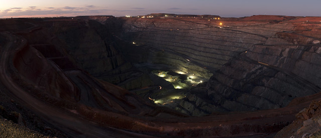
Today was a very slack day. We got up late and headed over to Boulder for the Market Day, but we arrived just as it was all packing up. Also, due to the earthquake last year, a number of the other possible attractions are still closed. After a brief look around we headed again up to the Super Pit lookout, but this time with much more available light.
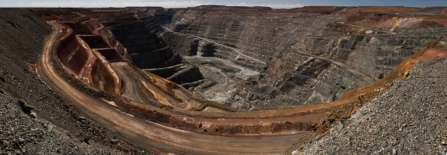
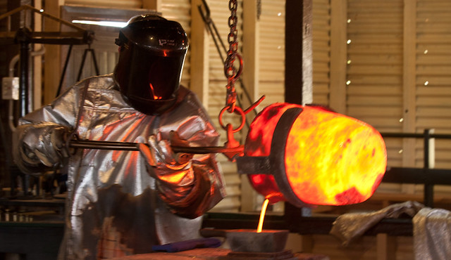
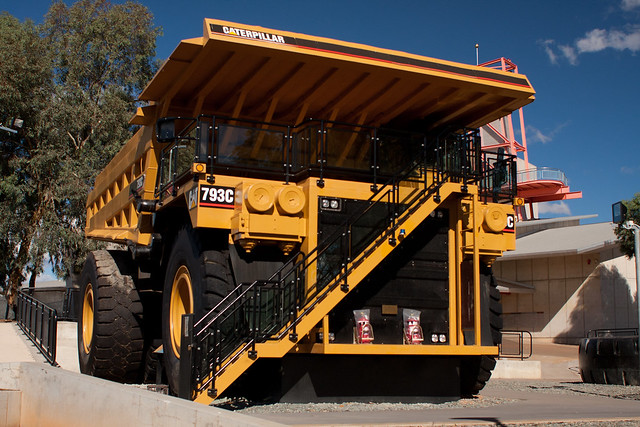
The remainder of the afternoon was spent over at the Mining Hall of Fame where we viewed many old pieces of mining equipment, a gold pour, and went in the cab of a Cat 793C dump truck.
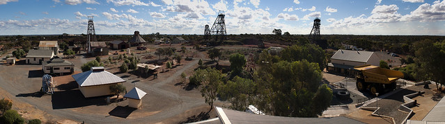
When I was here 18 years ago we definitely watched a gold pour and I am pretty sure we did one of (possibly only at that time) the underground mine tours. Since then they have built a large modern building that contains the actual hall of fame along with other displays and a small theatre showing a variety of area related segments. The 793C dump truck is a recent (mid 2010) addition and while it isn’t a complete truck (no chassis or engine) it was quite interesting looking in the cab and seeing normal wear and tear damage to the tray above the cab.
Tomorrow we are going on the two and a half hour superpit tour before getting back on the road, destination Balladonia.
Tagged with: road trip
Saturday, March 19th, 2011 at 10:20pm
All the way from Adelaide to Perth we followed the coast, so much so that I was getting a bit tired of beaches, coves and bays. However now, our second day out from Perth, the coastline is only a memory as we are well and truly inland where the two most important things are water and gold. Water so you can survive, and gold to give a reason to be here. On the way we also passed through the wheatbelt, but the area from Southern Cross through to Kalgoorlie is about gold.
After checking out of the motel in Hyden our first stop was The Humps, another rock formation a few kilometres north of Wave Rock. We declined the walk up the rock, instead just visiting Mulcas Cave, a cave formed from a hollow boulder that is filled with aboriginal art.
Continuing north on the back roads leads directly to Southern Cross on the Great Eastern Highway. Though minor roads, this route is fairly well travelled as the other route (the only way that Google and others know) is about 300 kilometres longer. The direct route took us past the town of Marvel Loch and its large pit mine before we stopped for lunch at a roadhouse in Southern Cross. We had hoped to find something better for lunch, but it is Saturday and nothing appeared to be open.
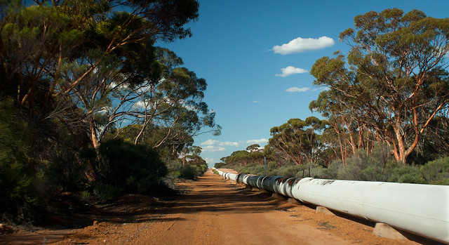
Starting near Perth at Mundaring Weir and running all of the way to Kalgoorlie is a water pipeline, as you drive you see it running along the highway, sometimes dropping below ground, or at other times jumping to the other side of the road. The Golden Pipeline Heritige Trail follows the pipeline as well as highlighting places of historic interest along the pipeline. It was due to this trail that we stopped at the old pumping station no. 6 and also detoured to an old dam at Karalee Rock.
This is a dam that was used before the pipeline to supply first people travelling along the road and then supply trains along the railway line. A wall was placed around a large granite rock to capture water and feed it to the dam along an iron aqueduct.
The heritage trail also led us along the pipeline instead of the highways for a longer than expected section, this also included a short section along what we believe is the old railway alignment.
Eventually we arrived in Coolgardie where we had a brief look around before continuing on to Kalgoorlie. Our first stop (after checking into the motel) was the Mount Charlotte Reservoir and Lookout, it was only later that we learned that the large number of photographers were photographing the moon was because it was a supermoon. Our second stop was at the Super Pit lookout where we managed to get some shots in the fading light.
Tagged with: road trip
Friday, March 18th, 2011 at 08:39pm
We are now a day or two (because it is still not set in stone when we will arrive back) past the mid point of this trip. Today, by leaving Perth, we have started heading in a homeward direction. Of course we started the day by heading from our motel near the Perth CBD out to Cotteslow and north to Scarborough before looping around the top of the city to get to the Great Eastern Highway. But we still couldn’t head directly to Hyden with our path meandering a bit. Towns on the way including Northam, York, Beverley and Brookton before getting on the road that actually leads to Hyden.
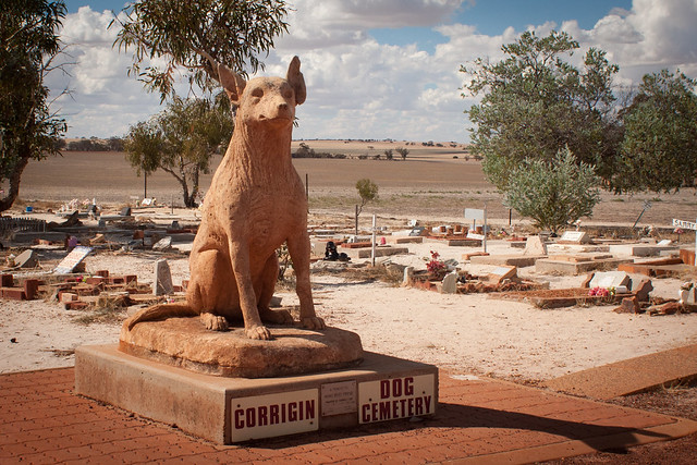
After passing through Corrigin with its Dog Cemetery and world records relating to number of utes with dogs in them, we arrived in Hyden in the late afternoon. Checking into the motel brought back memories as the rooms are virtually identical to what I remember from 18 years ago. The television would have been CRT not LCD and the lights would have been incandescent instead of compact flourescent.
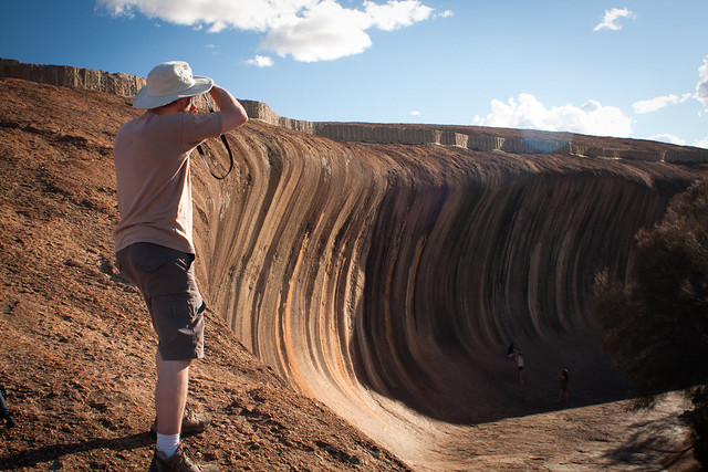
As the afternoon light developed we headed over to Wave Rock for photos of the wave section, the Hippo’s Yawn and the area in general. While the rock was how I remembered it, the carpark and other facilities were significantly developed since I was last here, I suspect the plaque saying that a politician opened something in 2005 has a thing or two to do with that.
Our initial plan was to go cheap and to cook some of the food we have been carrying with us, instead we were drawn in by the novelty of a resaurant where you chose your meat and then cooked it yourself. Like a barbeque, but not.
Tomorrow we are off to Kalgoorlie via the Emu Fence Road to Marvel Loch and Southern Cross where we will rejoin the Great Eastern Highway to Kalgoorlie. We have two nights in Kalgoorlie, a bit of a stuffup as the full day is a Sunday, the one day of the week that the two and a half hour Super Pit tour does not run. So we have that booking in for Monday morning, from which we will immediately head for Norseman and through to Balladonia which is where we left the Eyre Highway six days ago.
Tagged with: road trip
Thursday, March 17th, 2011 at 10:37pm
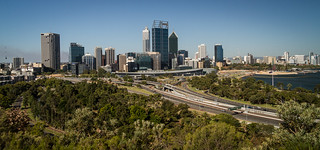
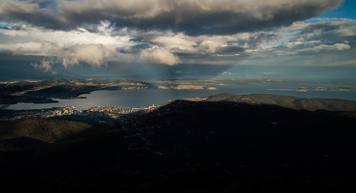
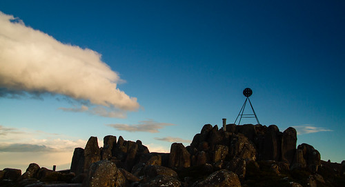
This afternoon we arrived in Kings Park a bit after 4PM after a brief exploration of the city. One of our first stops was near the war memorial for panoramas before the sun set.

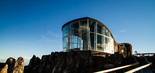
We then walked around the park, via the DNA tower (an observation town with twin spiral staircases) and returned to the lookouts at the Aboriginal Centre and the War Memorial. Once the sun did step we braved the ants and mosquitos for long exposure shots of the Perth CBD and you guessed it, more panoramas.

Tomorrow we are off to Hyden (a third of the way to Kalgoorlie) where we hope to get interesting shots of Wave Rock as the sun sets. This is only a few hours drive, so we are also planning to explore more of Perth before first heading to the town of York.
Tagged with: road trip
Thursday, March 17th, 2011 at 01:01pm
Today is our first real rest day and so far it has involved sleeping in, some midday television and writing this blog post. Damien is about to head out to catch up with a Perth base friend and we will meet up again later for late afternoon and evening shots at Kings Park. I have yet to decided if I will hang around the motel or if I will bother walking the seven kilometres to Kings Park in the heat.
So what did we do yesterday?
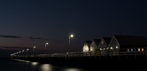
In the morning we did not leave Busselton until late morning as we returned to the jetty in daylight to walk up and back. Apart from experiencing the length of the jetty, there wasn’t much to see. What I did find interesting was the museum in the interpretive centre that showed the history of the jetty, including what sections were damanged by weather or fire.

Our next stop was a bit inland at the town of Donnybrook, apparently the centre of apple production in Western Australia. Our goal was to find a ‘big apple’ at the top of a tower. We didn’t find it, but as we were following directions as specific as “approximately 6 kilometres north of town” that is not surprising. On the main road north out of town we did see plenty of apple orchards, just no big apple on a tower.
We returned to the coast for lunch at Bunbury and a fuel stop at Australind before heading inland again. This time in search of water reservoirs, which we found, with some hopefull driving down poorly labelled bush roads that bordered on tracks. Our phones with GPS and appropriate maps were the key here.
At the Serpentine Dam we found similarities to dams and reservoirs in Victoria, extensive parking and picnic facilities that are run down and deserted. We can only imagine that years ago when these areas were first established they were a popular place for a day out, but no longer.
Eventually we came back to the coast at Rockingham, then followed the Coast up to Fremantle for dinner at the Little Creatures brewery.
Tagged with: road trip
Tuesday, March 15th, 2011 at 10:36pm
I was intending to upload a number of (possibly) good photos tonight. But somewhere between taking my last photo of the Busselton Jetty in the fading light and plugging the CF card into the laptop at the motel, the card had gone bad. That means I have probably lost all the photos I have taken today, thankfully it is only today, not also the last ten days as I have been making redundant copies every night.
I have attempted to use PhotoRec (which I have used successfully before) to recover the photos. But the card isn’t even coming up as a device, so PhotoRec is no help. I need to access the card at a very low level, which I can’t do here, but I may be able to do at home with an old CF to IDE adapter under Linux.
So what are the photos that I cannot show?
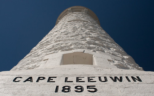
After staying at a motel in Augusta our first stop was the Cape Leeuwin Lighthouse where we climbed up to the top as part of the tour. We also stopped by the old waterwheel which was used to pump water up to the lighthouse outbuildings.
[pretend there is a photo of the lighthouse and/or water wheel here]
Next was a self guided tour of Mammoth Cave. We chose this cave because the self guided tour fitted in better with our fluid schedule, we didn’t want to just miss out on a scheduled tour and have to wait around for the next one.
[pretend there is a photo from within the cave here]
After the cave, and before hunting for somewhere to stop for lunch, we dropped by the Leeuwin Estate winery where we picked up some passengers, in the form of 750mL glass containers, before a quick spin through Margaret River, a failed hunt for somewhere to stop for lunch in Prevelly before finally stopping near Gracetown for that lunch. Another two passengers were picked up at the Flying Fish Cove winery on our way to Cape Naturaliste, where we failed to get near the lighthouse for photos as it was closed.
The day was rounded off by a light dinner opposite the Busselton Jetty followed by after sunset photos of that jetty.
[pretend there is a long exposure photo of the jetty at dusk here]
Tomorrow we are off to Perth, but we will start the day by visting the jetty (world’s longest wooden jetty) again (but going along it to the end instead of just photos from the shore) and likely end it with dinner in Fremantle before the first of two nights in Perth.
Update: I sent the CF card to a data recovery company who recovered the data. See my followup post for images to fill in the three gaps above.
Tagged with: road trip
Monday, March 14th, 2011 at 10:34pm
Today we achieved our goal of travelling from Albury to Augusta. Along the way we stopped for chocolate, tasted cider and toffee, walked in the tree tops and among giants, and finally climbed a 61 metre tree. Tomorrow, after visiting the Cape Leeuwin Lighthouse we will head north (there is no more west…) via some caves, some wineries, another lighthouse and then finally arriving at the world’s longest wooden jetty.
Throughout our travels so far we have noticed that it is the off season for tourists, but today that was driven home as at the chocolate factory, the cider/toffee factory and the Gloucester Tree we saw only two or three other people. When I previously visited the Gloucester Tree almost two decades ago I remember there being lots of people around the base and climbing the tree. That trip was over the Christmas/New Year period, not mid March during school term.
No photos in this post, as of the few that I took, I’m not that enthused about any of them. Later, once I am back home and have more time, I will look at them again.
Tagged with: road trip
Sunday, March 13th, 2011 at 10:07pm
Today was supposed to be a rest day with us sitting around doing nothing much in Albany. Instead today was taken up by the three hour walk up Bluff Knoll in the Stirling Ranges.
While only six kilometres to the top and back, it does take the advertised three to four hours as very little of it is flat. In fact I am doing it a disservice by calling it a walk, it was more like a climb up uneven wooden and/or rock steps.
Those following along would know that the initial plan was to do the climb first thing yesterday, it was the reason we chose to stay just north of the National Park. However, when we arrived at the Bluff Knoll carpark it was both raining and surrounded by low cloud. We decided against getting wet for no view, so instead headed directly for the coast east of Albany where we visited a few bays and beaches before heading to Albany for lunch.
The late afternoon was then consumed by a visit to Whale World (much expanded since my previous visit almost two decades ago) followed by the nearby attractions of the gap and natural bridge, some lookouts. We closed off the evening with shooting the sunset over the Albany Wind Farm, which unlink other wind farms we have been past, has plenty of lookouts and lets you get close to at least one wind turbine.

The weather this morning in Albany was promising for good weather at Bluff Knoll, so we drove the 80 kilometres back north and did the climb. Afterwards we headed out through the park on the Stirling Range Drive and the returned to Albany via Mount Barker. We picked up some takeaway dinner and took it up the Mount Melville lookout where there is an observation tower.

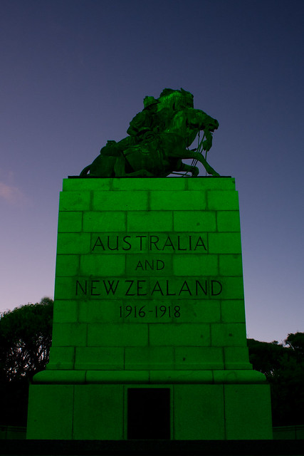
The sun wasn’t quite set so we continued wandering through town via the port, but were a bit to late to the Mount Clarence lookout where shots of Albany didn’t work, but shots of the green lit Desert Mounted Corps Memorial were interesting. We are now back at the motel and should be collecting our washing from the dryer soon.
Tomorrow we leave Albany with our destination being the Margaret River region. However it is currently looking like a late departure (need to stop by a Subaru service centre for some advice) and many stops (eg lunch with Elephants Rock cider in Denmark) will mean a late arrival into Augusta or Margaret River. This will push our visit to the Cape Leeuwin Lighthouse to the following day, ie no sunset, but we will adapt.
Tagged with: road trip
Friday, March 11th, 2011 at 11:22pm
By driving straight through Balladonia yesterday to get to Esperance, we actually gained a day in our schedule. After consideration we decided that we would reinstate a rest day at Albany. This rest day had been previously eliminated so we could stay just north of the Stirling Ranges in order to walk to the top of Bluff Knoll (three hours return) before getting into Albany. We now have an entire day in Albany to do nothing but relax.
After booking accommodation we set off, first having a look around the town area of Esperance and up to the Rotary Lookout on Wireless Hill, to the supermarket for lunch supplies and then out on the Great Ocean Drive. We would have liked to have stopped at the Esperance Municipal Museum, but its opening times of 1:30pm to 4:30pm didn’t work at all with our schedule.

It was at this point that we headed back into town, so I could pick up a polarising filter for my 28mm lens. This is something I have been meaning to do for a while, but why now? Because my main (on the camera 99% of the time) lens (Canon 17-85mm IS) developed the Err 01 fault yesterday (from dust and sand I assume). Reading up last night I found out that it was likely to be a problem with the aperture and after testing, I found that it was fine wide open so I decide to keep using it. But while driving around the Great Ocean Drive I discovered another issue with the autofocus, so that lens is out of action. My other lenses are 70-200mm (too long), 50mm nifty fifty (not zoom and too constrained) and the 28mm. While not zoom, it does give a decent field of view.
So, for the time being at least, the 28mm with a circular polariser is the lens I am using, but I am considering options. Could I post it to a Canon service centre in Perth for them to fix by the time we get to Perth? Could I find a secondhand 17-85mm to pickup in Perth? Could I buy a different/better lens? A different lens would be the 24-70L, but I have found that range to be too limiting on a crop body, and as I have no plans to move to full frame in the near future I don’t consider that an option. Whatever I do, it will affect the remaining two thirds of this road trip, even if it is to continue using the 28mm.
Speaking of the road trip, we were leaving Esperance before I decided to detour back for the filter.
Heading west from Esperance we decided to leave the highway and head down closer to the coast, after a few false starts along roads to Margaret Cove that became 4×4 recommended, then turned into tracks, we made it to Munglinup Beach. The beach itself was nice, but problems arose when we detoured down a side sand track and got ourselves bogged. An hour with the folding shovel didn’t help so I walked back to the camping area at the beach where I found a nice couple from Queensland with a 4×4. Appropriate use of a snatch strap moved the car the 10 metres back to more solid ground and all was well, except for the time and effort.
Now running out of time we headed straight for Hopetoun to have lunch in a park near the beach before intending to cut through the Fitzgerald River National Park. This didn’t happen, but this time it was becuase of all the signs indicating that the road was closed, so we returned to the highway at Ravensthorpe which we followed to where we are now, just north of the Stirling Range National Park.
We hope the weather tomorrow is good for the walk up Bluff Knoll in the morning, followed by the Stirling Range Drive in the afternoon and arrival into Albany.
Tagged with: road trip
Thursday, March 10th, 2011 at 09:19pm
I can tell you that there is very little to see on the road from Eucla to Belladonia, the only place we stopped (apart from for fuel) was the lookout above the Madura Roadhouse.

However along the way we did see a number of oversize loads containing mining equipment, the largest being two CAT 785C Mining Trucks stopped at the Cocklebiddy Roadhouse. The few other items of note include trees decorated with objects (underwear, shoes, etc), the old microwave repeater towers and the fibre optic repeater stations with their banks of solar panels.
As there was nothing to stop for, we made good time so we arrived at the Balladonia Roadhouse much earlier than expected. Instead of stopping for the night, we continued on along the Balladonia Road which cuts the Norseman corner and heads south west towards Esperance. This road starts out with big warning signs about it being a 4×4 only road that is not suitable for caravans. Of course we headed down it. It was a pretty rough road, but not a problem for us. Again there wasn’t much to see, a couple of big rocks and an old homestead.
Once we reached the coast a detour via Cape Le Grand National Park for panorama shots of Lucky Bay and sunset shots at Le Grand Beach rounded out the day before arriving at Esperance. Tomorrow will be the area around Esperance and then off to the Stirling Ranges, ready to (hopefully) climb Bluff Knoll the following day.

Tagged with: road trip
Wednesday, March 9th, 2011 at 10:32pm
Today we crossed over the border from South Australia into Western Australia, this mean that the timezone moved from +1030 (with daylight saving) back to only +0800, so we gained two and a half hours. But we are staying in Eucla (just over the border) and they have a local unofficial timezone of 45 minutes ahead of Perth. Despite this, all of our electronics have been updated to +0800.
So Eucla. We arrived here in the late afternoon (don’t know what time as we hadn’t figured out the local time at that stage) and after paying for a powered campsite and setting up the tent we headed down to the old telegraph station and jetty for the sunset. We timed it nicely and there should be some good shots. But I don’t yet know as as I type my photos are copying off the card and the priority is to get them backed up to the external drives before fiddling with them.
Where were we before Eucla? The Nullarbor. Not an aboriginal word as many seem to assume, but derived from the Latin for treeless plain. It was indeed laking in trees for much of it. Apart from observing the treelessness, we stopped off at a few clifftop lookouts, some with lots of facilities like at Head of Bight, others with a marked carpark, bins and warning signs and finally those thay have been closed due to unstable cliffs.
We also detoured north off the highway to the old highway and the Koonalda Homestead which, based on the information signs, served the highway until the 1970s. This made us start to wonder when the current road was built. It is harder to judge the age of things here as we have no idea how long it takes for things (picnic tables, bins etc) to deteriorate or roads take to overgrow.
In between leaving Penong we filled up at Nundroo and detoured via Fowlers Bay which was interesting as the original Main Street and buildings had to be abondoned (years ago) due to encroaching sand dunes.
Tomorrow the plan is to simply head to Balladonia with no planned detours along the way, the day after that is along the Parmango Road to Esperance, bypassing Norseman until our return journey.
Tagged with: road trip
Tuesday, March 8th, 2011 at 11:58pm
According to the plan we should now be camping at Cactus Beach, south of Penong. Instead we opted for the easy option and are staying in a cabin at Penong. There isn’t another town west of here until you get to Eucla just on the other side of the border to Western Australia. To the east is the town of Ceduna, the equivalent to the west being Norseman, well into Western Australia.
So how did we get here? After covering the area around Port Lincoln yesterday, today was about the west coast of the Eyre Peninsula. This meant following the entire length of the Flinders Highway, covering Coffin Bay, Lake Hamilton, Streaky Bay, Cape Bauer, and finally Ceduna. Unfortunately the weather wasn’t cooperating today, with much of it being dull and grey, but there were a few patches of nice weather so some photos were taken.
Tomorrow we will continue west, aiming to camp at or near over the border in Eucla. This will take us past many clifftop lookouts (one being Head of Bight) and we are planning to detour up to the old highway and the Koonalda Homestead.
On our return journey we will detour via Cactus Beach and Blue Lake (which we skipped today) in the hope that the weather will be better.
Tagged with: road trip
Tuesday, March 8th, 2011 at 12:28am
Today, day three of the road trip, was quite busy although we didn’t need to travel very far, only 161km, to our destination of Port Lincoln. We had planned it this way in order to spend most of the day past Port Lincoln in the Lincoln National Park.
We left Cowell at the reasonable time of 9am to first detour back to Lucky Bay (where the ferry would come in if it was not having a new ship built) to encounter an interesting 4×4 only track that we started to attempt in the Subaru. Fortunately we decided not to continue and resumed our journey south, but instead of following the highway, we followed the coastal road which took us to places such as Port Gibbon.
After some detours through Tumby Bay and Point Boston we arrived in Port Lincoln for lunch on the foreshore. Following a brief stop to check in to the motel, we set our sights on the Lincoln National Park, travelling all the way to the lighthouse at Donington Point to work our way back. Exploring some “recomomended for 4×4” tracks led us to bays and campsites such as the one at Fishermans Point.
It was around this time that the threat of rain turned into actual rain (late thunderstorms were forecast) so we decided against a 45 minute walk to the monument on Stamford Hill. Leaving the park we headed further away from Port Lincoln until we discovered that where we were trying to go was a drive called Whalers Way that was actually on private property and we hadn’t paid for a key. Despite this, the weather cleared up to give us a nice rainbow on the way back to town.
After dinner the sun was almost set which gave some interesting light, photos of which were taken from the Winter Hill Lookout as well as the Old Mill Lookout in town, but I think the best shots were taken from the motel of the grain terminal at dusk.

Astute readers should have noticed that each of these four images is a stiched panorama, this is because I am not running through my normal image workflow, instead I am just experimenting with Hugin. But as the results are good enough from default settings, they are worth sharing, even though I may redo them when I get home. Note however that these are just some of the possible panoramas I am shooting. There are many more.
Tomorrow we are off to the last town for 1,200km, Ceduna. At 350km from Port Lincoln is could easily be done in half a day, but there are many things to potentially see on the western coast of the Eyre Peninsula. Our intention is to camp somewhere past Ceduna, so we will likely to be without internet for a few days until we reach Esperance in Western Australia.
Tagged with: panorama, road trip
Sunday, March 6th, 2011 at 11:29pm
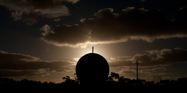
It is now the end of the second day of the road trip and we are sitting in a motel in Cowel, a town on the Eyre Peninsula. While the pressing need is for us to copy files of the cameras and onto the backup drives, I have also made a quick panorama using Hugin from shots I took at the Hummock Hill lookout of the steel pellet plant in Whyalla:

This is 22 handheld shots combined with the default settings. The only change I made was to tweak the alignment to make the horizon (more) level. A pretty good job for minimal effort.
Yesterday’s goal was to get from Melbourne to Adelaide with as little hassle and in as short as time as possible. We mostly succeeded after only leaving a bit later than planned, detouring via Serviceton to look at the old railway station, encountering locusts and having an interesting time following Google Navigation through the Adelaide Hills. Checking into a motel south of the city and then heading further south (yes, the wrong direction) to meet up for dinner with a friend of Damien’s (who is also from Melbourne, but visiting Adelaide) rounded out the evening.
Today we wandered around Adelaide for a while (via Glenelg and the CBD) while trying to find some open shops. We couldn’t comprehend that in Adelaide, most shops don’t open until 11am, by when we had given up and headed north. A stop at Port Pirie for lunch and a brief detour through Port Augusta brought us to the Eyre Peninsula where we were planning to spend the night at either Whyalla or further along at Cowel. Although detouring out to Fitzgerald Bay and stopping for dinner in Whyalla, we made it to Cowel.
The plan for tomorrow is to get to Port Lincoln with enough time to also visit the Lincoln National Park. This will give us more time on the following day when we head up the other side of the peninsula towards Ceduna. This will be the first of three nights camping instead of staying in a motel. On the following day we will also be out of mobile coverage, so no identi.ca/twitter/facebook updates or blog posts until we reach Esperance.
Tagged with: panorama, road trip
Friday, March 4th, 2011 at 11:48am
This time tomorrow, Damien and I should be heading in a westerly direction out of Melbourne. The first day of a three week / 8,000km plus road trip from Melbourne to Perth and back.
View Larger Map
Not much about the trip is set in stone as we don’t know how long we will stop (if at all) at various places. To reflect this we have lists of motels, caravan parks and campsites, but very few actual bookings. If needed we will call ahead a few days in advance, but that is all.
One thing that (some) people seem surprised about is that we will only be spending a single day in Perth. Yes, one day out of three weeks and that is a rest day to catch up on things like washing clothes (there are other rest days as well). This is a road trip, so it is about the journey, not about the destination, Perth is just one of the stops. Driving across Australia is not something you do often, you can always fly over to Perth later.
The last few weeks have been busy with final planning which should all come together tonight with the final pack of the car. But I thought I should mention the technology that we are considering essential:
- Three still cameras (SLR, compact and a bridge)
- One HD video camera (mounted to the windscreen..)
- Three (maybe four) phones (one of mine, the others Damiens)
- GPS unit (in addition to one in the phones)
- UHF radios
- Two laptops
- Telstra internet dongle
- External drives for backup
- Batteries and chargers
I will try to keep identica/twitter/facebook updated, and maybe throw in a blog post or two. But we know that there is zero mobile coverage across the desert (on the train line yes, but not down at the highway) so it will become quiet on the Ceduna to Esperance and Norseman to Ceduna sections.
If nothing else, I expect to be back in three weeks with lots of photos, hopefully some of them good.
Tagged with: photos, road trip
