Blog entries tagged with "gps"

Losing track of time

Sunday, August 25th, 2019 at 10:15am

At the time I posted about the GPS Week Number Rollover my Garmin eTrex Vista HCx would still work, just with a date that was 1024 weeks too early, but then it stopped recording a timestamp at all which made the track useless. I found this out the hard way when I got home after taking photos that the GPX file for that day couldn’t be used. I was able to recover the track for that day from the device memory using the Garmin software, but that is a hassle to do on a regular basis.

So I ended up doing what I predicted, I picked up a Garmin eTrex 20x which is an updated version of what I had.

Although I don’t plan to use it for mapping, just in case I loaded on maps for Australia created from OSM data. I initially put these on a microSD card, but later loaded them directly into the device.

With the older device I had it configured to automatically write the track log as GPX to the microSD card, so at the end of the day it would be quick to pop off the back cover, pull out the microSD and insert it into a card reader.

This approach was not going to work with the new device.

First the microSD card is not as easy to access. It is below the batteries (not that much as an issue as I would swap the batteries at the end of the day anyway) but it is not in a spring loaded push slot, instead it is under a sliding cover and awkward to extract.

The main issue however was that I couldn’t work out if I could configure it to write automatically write a GPX log. I did find that I could save the current track (resetting the track at the same time) and then if the device was in USB mass storage mode find the GPX file of that saved track.

So it looks like my new geotagging process will now include:

  • at the start of the day:
    1. when I take the sync shot of the GPS time, also clear the current track
  • at the end of the day:
    1. save the current track
    2. plug the device in via USB
    3. browse to the GPX folder
    4. copy the GPX file with the saved track

Tagged with: ,

GPS Week Number Rollover

Saturday, July 27th, 2019 at 07:42pm

A quirk of the GPS system is that it uses a week counter to represent the date, this can only represent a maximum of 1024 weeks, so every ~19.7 years it resets to zero, known at the GPS Week Number Rollover.

The second rollover was earlier this year and there was plenty of media coverage as well as government statement at the time. I also saw a number of YouTube videos about it, such as this one from Matt Parker:

The handheld GPS unit I use for geotagging photos is from Garmin, so I was particularly interested in what they had to say about it. Well that is non-specific… is my device (obtained second hand twelve years ago and last firmware update was ten years ago) part of the “vast majority” that “will handle the WNRO without issues”?

I wasn’t that concerned so opted for a wait and see approach, so when I used it in late April I was pleased to see that it was logging the correct date. However when I used it in May and June I noticed that there would be spurious log files, as if it was starting up with the wrong date and then adjusting to be correct.

Today was my first time heading out to take photos since June, so I was disappointed to find that my GPS device is now stuck in 1999. The location and time are correct, just the date is wrong.

When geotagging my photos from the GPS track I would specify the time offset between the camera (local time of where I was) and UTC, so for Melbourne at UTC+10 that is an offset of -36000 seconds. Since the date it is logging is now 1024 weeks out, I could specify an additional offset of -619315200 seconds…

The more reasonable option is to look for a new GPS unit, but with my key requirements of AA (or AAA batteries) and a GPX file written to an SD card I suspect that I might just end up with a newer version of what I have. I have seen some nice small dedicated GPS logging devices, but I want to be able to easily swap in fresh batteries or don’t want to be forced to use their software to access the tracks.

I had a quick look at eBay to get an idea of what might be available, saw plenty of devices like what I already have, but don’t see any mention of GPS Week Number Rollover in the item descriptions…

Tagged with: ,

Geohashing again by bicycle

Sunday, January 11th, 2009 at 08:48pm

I went on my fourth Geohashing expedition yesterday. While I have previously mentioned the first one and the second one, I haven’t mentioned the third one as there wasn’t much to say.

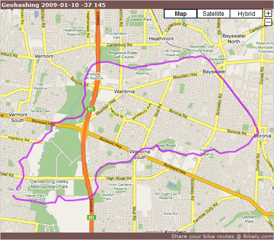
After looking up the location and seeing that it was not too far away in Boronia, and more importantly quite close to the Blind Creek Trail, I decided to ride over to arrive just before 4PM. I waited around for about 20 minutes, but no one else arrived so I left.

Instead of heading back the way I came I continued on to the Ringwood-Belgrave Rail Trail and headed towards Bayswater and the Dandenong Creek Trail:

Bicycle Path - Gardiners Creek Trail (upper) at Bikely.com

Tagged with: , ,

Geohashing, this time with other people

Saturday, October 18th, 2008 at 04:50pm

This afternoon I drove down to Fountain Gate to complete my second Geohashing expedition. Amazingly shortly after I arrived two other people arrived. We hung around for about half an hour and even picked up some rubbish.

More details (including photos) are on the expedition page.

Tagged with: ,

A response from Garmin

Tuesday, September 9th, 2008 at 04:51pm

A few days ago I ranted about the trouble I had unlocking Garmin maps and I have an update.

Aparrently they did recieve me question (I still can’t see it in their support site) because today I received a response via email. They didn’t address my problems with the site, instead they just told me what my unlock code is and where to manually enter it to unlock the maps.

I suppose any response is better than no response, but that was only one of my issues with the unlock process.

Tagged with: ,

My first geohashing expedition

Monday, September 8th, 2008 at 10:41pm

Ever since The Alogorithm was first announced I have wanted to go on an expedition.

Last Saturday I was a bit late in checking for the days location (it was after the official 4pm meetup time), but as it was so close to home I had no option but to ride over. More details can be found on the expedition page which I have just finished updating with my info and photos.

Tagged with: , ,

The Garmin map DRM annoys me

Saturday, September 6th, 2008 at 01:30pm

Tomorrow I’m going for a ride with a friend, so earlier in the week I set about installing the Garmin map software so I could load the route into my GPS unit. I had it installed previously, but that was before I built myself a new computer.

So over I went to the Garmin site to download the latest versions of the USB drivers, the firmware update tool, and MapSource, the mapping program. Installing these went fine until I installed the Australian maps that I had bought at the start of the year.

It wouldn’t let me unlock them. Specifically it wouldn’t let me retrieve the previous unlock codes.

The version of MapSource that I was using was 6.14.1 and the unlock procedure was different than I remmembered it. Instead of giving me an option to restore the unlock codes from a backup file, the only option was to unlock online.

After installing a Garmin plugin in Firefox the unlock web page was able to detect my GPS unit and, according to the instructions, all I needed to do was enter the serial number of the unit and click ‘Retrieve Unlocks’.

No: “Unable to unlock map(s) for unit”

Why didn’t that work? The maps are still loaded on the unit (but not viewable in MapSource) and when I login to the Garmin site it correctly tells me what unit I have AND what maps are installed/unlocked.

Maybe they’re not competent to support multiple browsers so I try Internet Explorer. Still unable to unlock so that’s not the problem.

How about the support section of their site? I find a question about unlocking after a computer crash which seems promising. However the answer talks about an unlock wizard, more like what I remember from last time, which appears to be have been replaced by the web based process.

As I was planning to take a route drawn up in Bikely and my unit still has the maps installed there was no urgency in viewing them in MapSoruce, so I decided to submit a question. Which does lead to a browser support problem.

I first tried to submit my question in Firefox. But clicking submit didn’t seem to have any effect. The page that is supposed to “Access and manage your correspondence with Product Support” showed nothing. Had the question been submitted? Aparently not as when I tried it in Internet Explorer I got a success screen. But it still wasn’t being shown back to me as correspondence.

It is now 48 hours later and I hadn’t heard anything so I decided to try something different. Revert back to the version of MapSource that I had previously used (I had kept the 6.13.4 installer) and see what the unlock process is like there.

It was what I remembered and this time there was the option to use my backup file and the maps were unlocked. Yay! I then reinstalled 6.14.1 and the maps stayed unlocked. Another yay!

So what was good about this:

  • Garmin does update their software

But there is more bad:

  • The new web based process didn’t work
  • The support info was out of date
  • The support site didn’t work properly in Firefox (2.0.0.16 if you were wondering)
  • The support site works more in Internet Explorer (7.0.6001) but maybe not entirely
  • If they did receive my question, then two business days is more than enough for at least an acknowledgement that they received it

I have it working now, but who knows if others have the same problems and if they are, then how would Garmin know if the channel for asking for help doesn’t seem to work?

Tagged with: , ,

Playing with my handheld GPS unit

Tuesday, November 13th, 2007 at 08:12pm

After I posted my thoughts on getting a handheld GPS unit last week I realised two things:

  1. I do not need the electronic compas or barometric altimeter. So I could step down from the eTrex Vista Cx to the eTrex Legend Cx.
  2. I do not really need the basemap in the unit to be for Australia. Most of the units I was looking at on eBay were US models that had Australian maps loaded.

So on Sunday I was the winning bidder for an eTrex Legend Cx with Australian maps for two thirds of the cheapest price I could find locally.

It arrived today and for the past couple of hours I have been playing around with it. What do I now know?

  • The Australian maps take up 96MB of the 128MB microSD card (included instead of the supplied 64MB card) so it might be necessary to get a bigger card, especially if I do by detailed maps. Currently a 2GB card is under AU$40.
  • Logging the track to the card means they are available to any computer without special software by putting the unit into mass storage mode.
  • The Trip & Waypoint Manager software that came with the unit lets me upload a route to the unit. The track log can also be downloaded using this software.
  • Routes exported from Bikely as GPX need modification (stripping out elevation tags) before the software will accept them. I just used gvim but a simple perl script should also do the trick and could automate other cleanup tasks.
  • With only 500 possible waypoints, any route that I plan out using Bikely will need to be drawn fairly coarsely. But that is ok for a plan.

Tomorrow is the monthy Melbourne Perl Mongers meeting so I won’t be riding to work. But I will take the unit with me to record my journey anyway. I also bought a bicycle mount, from a different seller on eBay, that should arrive in a few days, ready for my first ride with a GPS on the weekend.

Tagged with: , ,

Thinking about a handheld GPS unit

Thursday, November 8th, 2007 at 09:52pm

Over the last few years I have periodically thought about getting a handheld GPS unit to take with me on rides. Not for navigation with maps, but to record the ride for later review.

Although Ride to Work Day didn’t get any new participants from our office this year, I did suggest a couple of routes using Bikely. While I was doing this I decided to have another look at Google Earth, in particular loading in kml files exported from Bikely.

In turn, this renewed my interest in a GPS unit.

Since I wasn’t interested in mapping, just logging, I had a look at a GPS unit designed for cycling, the Garmin Edge series of units. As the new models with maps are not yet available, I was looking at the Edge 305 which also has a wireless cadence/speed sensor so it does not rely solely on GPS for speed.

What were the positives?

  • It is designed for cycling.
  • The default behaviour is to log where, when and how fast you were going.
  • It seemed to be possible to load a route (originally drawn up in Bikely) to follow onto it.

I almost made an impluse purchase, but there were some negatives:

  • A battery life of 12 hours wouldn’t suit for day to day use as a replacement for my current bicycle computer. It has been years since I replaced the battery in that.
  • It wouldn’t be useful away from the bike.
  • The route capabilities seemed to be a hack for what I wanted to do.

Because of these I went back to looking at handheld units that are primarily designed for bushwalking or similar:

  • It wouldn’t be tied to the bike, so I wouldn’t be obliged to use it day to day.
  • There was a much wider range of options.
  • It could have the capability to load maps.
  • The maps could even be used for driving directions.

At this point I recalled that a co-worked had gotten such a unit a year ago so at the next opportunity I asked him about it. It turned out that one of the uses he has for his unit is to take it on rides with it mounted on his handlebars.

The specific unit he has is the Garmin eTrex Vista Cx that was, at the time, the top end model that Garmin has for that style of unit. It has a (relatively) high resolution colour display, mapping capability, electronic compass and a barometric altimeter.

This does seem to have all the capabilities I need. Including some that I might not. Since the Vista Cx is fairly expensive (over AU$500) a cheaper option is the Legend Cx (around AU$450) which appears to be identical except it does not have the compass or altimeter. After you add another AU$250 for Australian street maps this does start to become expensive. Considering that navigation units for cars can be had for around AU$400. But they don’t have the non-road and logging capabilities of a “proper” GPS unit.

So what are my actual requirements? My current thinking is that I would do something like:

  1. Plan the ride out in Bikely or Google Earth
  2. Export the planned route and load it into the GPS unit
  3. Go for the ride. The loaded route will show if I deviate from the plan and the unit will be logging where I actually go.
  4. Export the log from the unit and use it to more accurately show the route in Bikely or Google Earth.

Over time I would have a series of logged routes that I could view through Google Earth.

For now I will continue investigating my options. Including whether to get it from an actual store, an online store, or through eBay which is the cheapest option I have seen. But the support may not be the best…

Tagged with: ,