Blog entries tagged with "commute"

Last bicycle commute for the year

Thursday, December 24th, 2015 at 08:58pm

Today was my last day of work for the year, but more importantly yesterday was the last time I would commute to work via bicycle in 2015. I am happy that I have mostly kept to my target of riding to work twice a week, some weeks I manage three times, but others only once or for a couple I didn’t ride at all.

I have been tracking all of my rides via an app on my phone, so if I wanted I could go back and see exactly which weeks I did not meet that target. What I did look up was the total distance I have ridden: 3,938km across 187 rides. While almost all of this is the commute, there have been a handful of other rides, there are six days left in 2015, a ride or two should get me up to 4,000km.

Next year I will up my target, I will aim to ride three times a week…

There is no nice summary for it, but something else I noticed while looking back through the rides in the app is that my average speed has changed. The ride in the morning (downhill following the creek/river) has changed from an average of 25km/h up to an average of 27km/h, with the ride home (uphill along the creek then a climb at the end) changing from 20km/h to 22km/h. It is not much of a change, but nice to see.

I have also been tracking my walks through the same app, it shows 89 walks for a total distance of 488km. I also expect that to get up to 500km by the end of the year.

Tagged with: , ,

You need to complain for a myki refund

Monday, May 11th, 2015 at 10:00pm

In the six months that I have been catching the train to the city I have not had any myki issues. That was until last Tuesday when all the gates at the Elizabeth Street entrance to Flinders Street were open with the validators disabled. This meant that I couldn’t touch off to get the free early bird fare.

Later in the week I submitted a complaint and today I received a response saying that due to equipment malfunction I would get a reimbursement to my account. This is good for me, but what about all the other people using that exit on Tuesday? Do they all need to submit a complaint?

Tagged with: ,

Twice a week for four weeks

Friday, February 27th, 2015 at 08:57pm

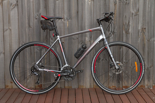
After getting back on my bike I quickly realized that as it needed a bit of work (new chain and cluster, new brake pads, etc) it was time to invest in a new one. After some research online and at the bike shops in the area I decided on a flat bar road bike:

New bike for 2015

In the four weeks that I have had it I have ridden to work twice in each of those weeks. It is a much smoother ride than the old bike, but I have only cut a few minutes off the ride to work. The ride home is steadily reducing in time, but I put that down to riding more rather than the new bike.

I have also been fine tuning the route, trying different things to see what is easier. As the bulk of the route is along bike paths there are only a couple of possible variations at the start, middle and end.

Near Alamein Station I tried Dent Street for a while, but as I found the rough concrete and speedbumps annoying I reverted to Baird Street. Dent was also fairly busy with car traffic on the ride home.

When almost at the city I now head up the Exhibition Street extension (footpath is a shared path) and then down Flinders Street. Before 7AM there isn’t much traffic and it is much better in regard to pedestrians than going past Flinders Street Station along the river.

On the way home I did try heading back up Flinders Street before making a hook turn into Swanston Street and then down beside Federation Square, but around 4PM the traffic is getting busy and it was annoying waiting at the lights. One time I tried crossing over the river and riding in front of Southbank and the boatsheds, there were even more pedestrians to contend with than the path between Flinders Street Station and the river.

In the morning I still start off by heading down High Street Road as that is a nice direct downhill stretch with very little traffic at 6AM. On the way home I leave the bike path to head up towards Jordanville Station to follow the railway line up to Mount Waverley Station.

Initially my plan was to ride at least once a week, but I think I can reasonably set the minimum to be twice a week…

Tagged with: ,

Back on the bike

Saturday, January 10th, 2015 at 09:32pm

Today I rode my bicycle into the city. In itself that isn’t much, but to me it is both the first time I have gone for a ride in over six months (not sure when, but before my US trip last July) and has removed another excuse for not cycling to work. Currently the weather forecast for Monday is humid with late showers, so it looks like I will be riding in. Whether I ride home or catch the train with my bike will be a question for later.

In the past when talking about rides I have used Bikely but since the last time I used it it has become broken. There are two versions of the interface, in the old interface you can draw out a new route but then you cannot save it, while in the new interface you can save your route but I cannot find where to edit an existing route. I also was not able to import a GPX file as a new route like I used to, it says there was an error.

Instead here it is in a Google Map created from this KMZ file:

This is a mix of on-road and bike paths:

  • Along High Street Road taking advantage of the downhill to maintain speed
  • Onto the Gardiners Creek Trail, including crossing under Warrigal Road
  • At Alamein Station skip a section of the Gardiners Creek Trail by using streets that a more direct
  • Rejoing the Gardiners Creek Trail and follow to the end (including the new bridge near Kooyong)
  • Join the Main Yarra Trail and follow it past Federation Square and Flinders Steet Station
  • Loop around to the bottom of Queen Street to the office

The distance was 21.7 kilometres, with a moving time of 56 minutes. The total time was just over an hour as I did briefly stop a couple of times. I expect that as I get into a routine that time should reduce a bit (and I won’t need to stop).

I expect to refine the route over time, should I get back on the Gardiners Creek Trail a little bit earlier or should I use some of the gravel sections instead of crossing back and forth over the creek? One mistake I did make was to miss the turn to the lower path next to the Yarra at Birrarung Marr which meant I had more pedestrians to negotiate and then had to zigzag down. Now I know where to go (turn next to the Angel sculpture) and at 7AM there should be very few pedestrians.

Right now I am committing myself to riding at least once a week, but hopefully more. This will depend on what else I have on, for example in the coming week what I have on the evenings means I will not be able to ride on Tuesday Wednesday or Thursday. So Friday is still a possibility…

Tagged with: , ,

The cost of the commute

Wednesday, June 18th, 2014 at 11:19am

If things stay on track, when I return from my US trip I will be one of the many that commute to and from the CBD every day. This is quite a change from the short commute I had when I worked at Monash Uni for all of those years.

A few weeks ago I decided that it was highly likely that I would end up getting a job in the CBD, so I looked into what options there were and what they would cost.

Driving all the way is definitely out, and while long term cycling should be an option, in the short term I will commute via train. But even that has variations:

  • walk/drive to the nearest station which is in zone 2
  • drive to a station in zone 1
  • Early Bird – free travel before 7am
  • Myki money versus Myki pass (specifically a 33 day pass to cover 5 working weeks)

Others have already done some of these comparisons (eg Ways to save with myki) but I didn’t see the scenario of weekday only travel, no regular weekend usage.

For the scenario of traveling every weekday the weekly costs I got are:

 Zone 1Zone 1+2
Early bird morning, 2 hour afternoon$17.90$30.30
Myki 33 day pass (starting on a Monday)$29.04$44.88
Daily tickets$35.80$60.60

Committing to using early bird every day of the week does give the lowest cost at half that of daily tickets, but you need to be able to have an early start at work. The pass is cheaper than ad-hoc daily tickets, but not as much as early bird and you commit to the pass for five weeks at a time, even if you do not use it. If you cannot use early bird at least twice a week (three or more for zone 1+2) then you are better off with a pass.

As it happens I will have 7AM starts, so early bird is the go both for price and the flexibility for when I do eventually start riding at least some of the time.

That is the type of ticket, but what about the zones? It is clear that getting to a zone 1 station is cheaper for the ticket, but what about the cost of getting to the station.

There are three likely stations that I would use, with different timings:

 Home to stationStation to CBD
Walk to closest station (zone 2)1.3km, 15 minutes30 minutes
Drive to next closest station (zone 2)2km, 5 minutes33 minutes
Drive to zone 1 station8km, 15 minutes23 minutes

I’ll probably drive to the zone 1 station. Even though that would cost around $1.40 in petrol (compared to $0.40 to the zone 2 station) it still comes out ahead of the zone 1+2 cost and means less time on the train itself and I don’t expect there to be much traffic at 6AM.

Of course all this is just theoretical, what actually happens in eight weeks time might be different.

Tagged with: , ,

What is a bicycle lane?

Thursday, October 31st, 2013 at 08:58pm

It didn’t take me long after moving into my place in Mount Waverley to determine what while there were options (length, hills, shops) for my bicycle commute home, the commute to work was via Lawrence Road and Pinewood Drive:
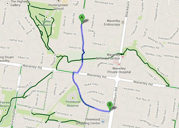
While this still involved a decent hill, it was fairly steady and didn’t have anywhere near the traffic of Blackburn Road. What wasn’t clear was whether Pinewood Drive had bicycle lanes. There were no signs or markings, just wide parking lanes, yet the council’s maps of bicycle paths (local copy) showed it as having on-road marked lanes.

In February 2011 I contacted the council and then in April 2011 they painted bicycle logos. However they never installed signs, which means they were not legally (according to VicRoads information) bicycle lanes.

For a week after they painted the bicycle logos I used the “lanes” but after three near-doorings I didn’t use them again, but I continued to ride along Pinewood Drive.

A few weeks ago the council resurfaced Pinewood Drive and once they started to mark our for new lines I asked the council via twitter if the new lanes would continue across intersections. The answer was yes. But once they started marking the actual lines I realised my question was too narrow. Instead I should have asked if they would follow current design standards in general, not just one specific part.

It isn’t as if the council’s Walking and Cycling Strategy (local copy) – adopted 30 April 2013 – has a section (6.3, page 22) about ensuring consistent design standards. Oh wait, yes it does. See page 14 for ‘Ensuring consistent design standards’ and action item 18 references Austroads and VicRoads guidelines.

Those guidelines are available online: VicRoads – Design Standards for Bicycles and Austroads Guidelines. I haven’t bothered to register to get the free PDF download from Austroads, since the Cycle Notes No. 12 – Design Standards for Bicycles (local copy) looks to have sufficient information.

This is the third page from that document:
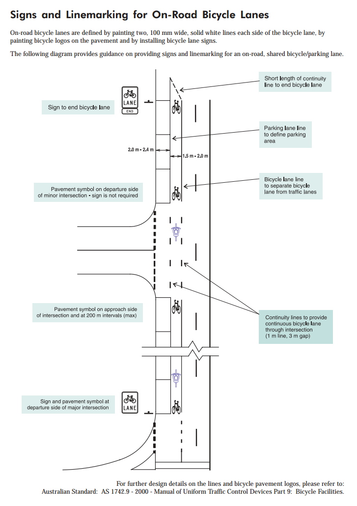
To me it provides a pretty good overview of how a modern bicycle lane should be marked out.

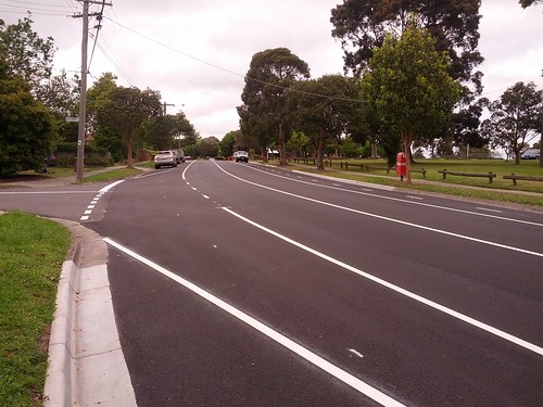
Here are two photos of the new markings (note quite complete) in Pinewood Drive:
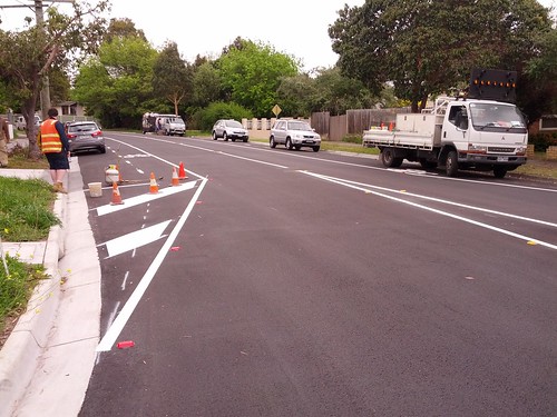
Pinewood Drive and Waverley Road

Pinewood Drive and Illuka Cres

So what issues do I see?

The text at the top of page 3 in cycle note 12 says that bicycle lanes are defined by:

  • painting two, 100mm wide, solid white lines on each side of the bicycle lane – nope, left hand side is broken line
  • painting bicycle logos – ok, there are some of these, but more later…
  • installing bicycle lane signs – not yes, maybe they will be installed this time?

Referncing between the page 3 diagram and my two photos:

  • Bicycle logo is not at the start of the lane.
  • Solid lines and a painted island prevent entry into the bicycle lane. Has this been just marked wrong? See the spray painted line…
  • Instead of a parking lane line to define the parking area, there is a broken line
  • Continuity lines (there is only a single line) do not continue through the intersection. Though the marking out has two lines…
  • The end of the bicycle lane (under the painters truck on the other side of the road) does not end of a short length of continuity line.
  • Why is the end of the parking bay angled, not squared off as in the diagram?

This post is partially being written as my way of explaining my concerns to the council, it will be interesting to see what happens. And I haven’t even covered the eastern end of Pinewood Drive (between the school crossing and Blackburn Road) which the council’s map shows has having marked bicycle lanes, yet…
Tagged with: , ,